Garmin Pilot Adds Obstacles And Terrain For Android | Aero-News Network
Aero-News Network
RSS icon RSS feed
podcast icon MP3 podcast
Subscribe Aero-News e-mail Newsletter Subscribe

Airborne Unlimited -- Most Recent Daily Episodes

Episode Date

Airborne-Monday

Airborne-Tuesday

Airborne-Wednesday Airborne-Thursday

Airborne-Friday

Airborne On YouTube

Airborne-Unlimited-06.23.25

Airborne-NextGen-06.24.25

AirborneUnlimited-06.25.25

Airborne-AffordableFlyers-06.26.25

AirborneUnlimited-06.27.25

Wed, Jun 24, 2015

Garmin Pilot Adds Obstacles And Terrain For Android

Overlays For VFR Sectionals, IFR Charts

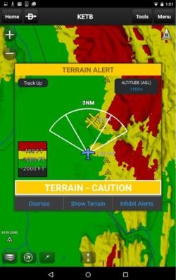
An updated version of the Garmin Pilot app for Android, which incorporates the display of both terrain and obstacles overtop Garmin’s rich, dynamic navigation maps, VFR Sectionals, IFR high and low enroute charts, is now available. These terrain and obstacle overlays display visual alerts of potential hazards and enhance situational awareness, particularly in unfamiliar environments.

In addition to terrain and obstacles, version 4.3 for Android supports X-Plane 10 and other compatible simulators, offers the option to display density altitude information and now includes a new subscription options.

Garmin Pilot version 4.3 provides pilots with the option to overlay terrain and obstacles simultaneously on the moving map page, while retaining the ability to view pertinent in-flight navigation information. Terrain and obstacle information can be overlaid and viewed in track-up format, ensuring flight plan information is upright and easy to read. Pilots also have access to a dedicated terrain page, so they may view terrain and obstacles in an arc or 360-degree view. 
 
With a premium upgrade, intuitive colors incorporated within Garmin Pilot help pilots easily discern their proximity relative to terrain. Pilots are provided visual caution or warning alerts when operating near obstacles or terrain that may be of potential conflict. Terrain data leverages highly detailed data found within Garmin avionics and portables and is available in various resolutions to provide pilots the flexibility to select the level of detail they prefer for their device.

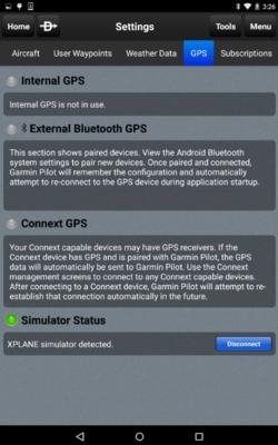
Garmin Pilot now supports X-Plane 10, as well as a variety of other compatible simulators. Customers may launch X-Plane and connect Garmin Pilot to the simulator. Once the connection is made, Garmin Pilot conveniently sends AHRS information to display flight plan information within the application and the simulator.

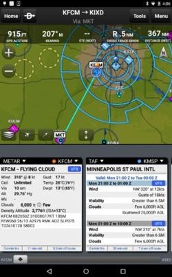
Pilots can optionally display density altitude information within Garmin Pilot in the METAR widget. By viewing widgets in split screen mode, density altitude is calculated and displayed to provide pilots information that is critical to aircraft performance.

The features of the upgraded packages have been enhanced to include visual and aural terrain and obstacle alerting.

New packages include:

  • VFR Premium - $49.99 annually, which adds geo-referenced SafeTaxi diagrams along with terrain and obstacle alerts
  • IFR Premium - $74.99 annually, includes features within VFR Premium along with geo-referenced FliteCharts

The latest version of Garmin Pilot for Android is available immediately in the U.S. as a free update for existing Garmin Pilot subscribers. For new customers, Garmin Pilot is available in the Google Play store as a free trial for the first 30 days.

(Images provided by Garmin)

FMI: www.garmin.com/apps


Advertisement

More News

NTSB Final Report: Rutan Long-EZ

He Attempted To Restart The Engine Three Times. On The Third Restart Attempt, He Noticed That Flames Were Coming Out From The Right Wing Near The Fuel Cap Analysis: The pilot repor>[...]

ANN FAQ: Turn On Post Notifications

Make Sure You NEVER Miss A New Story From Aero-News Network Do you ever feel like you never see posts from a certain person or page on Facebook or Instagram? Here’s how you c>[...]

Classic Aero-TV: ICAS Perspectives - Advice for New Air Show Performers

From 2009 (YouTube Edition): Leading Air Show Performers Give Their Best Advice for Newcomers On December 6th through December 9th, the Paris Las Vegas Hotel hosted over 1,500 air >[...]

ANN's Daily Aero-Linx (06.28.25)

Aero Linx: NASA ASRS ASRS captures confidential reports, analyzes the resulting aviation safety data, and disseminates vital information to the aviation community. The ASRS is an i>[...]

Aero-News: Quote of the Day (06.28.25)

“For our inaugural Pylon Racing Seminar in Roswell, we were thrilled to certify 60 pilots across our six closed-course pylon race classes. Not only did this year’s PRS >[...]

blog comments powered by Disqus


Advertisement

Advertisement

Podcasts

Advertisement

© 2007 - 2025 Web Development & Design by Pauli Systems, LC