WingX Pro7 Version 7.0 Delivers Advanced Weather From Baron Services | Aero-News Network
Aero-News Network
RSS icon RSS feed
podcast icon MP3 podcast
Subscribe Aero-News e-mail Newsletter Subscribe

Airborne Unlimited -- Most Recent Daily Episodes

Episode Date

Airborne-Monday

Airborne-Tuesday

Airborne-Wednesday Airborne-Thursday

Airborne-Friday

Airborne On YouTube

Airborne-Unlimited-07.21.25

Airborne-Unlimited-07.22.25

AirborneUnlimited-07.23.25

Airborne-Unlimited-07.24.25

AirborneUnlimited-07.25.25

Fri, Jul 19, 2013

WingX Pro7 Version 7.0 Delivers Advanced Weather From Baron Services

Enhances IFR Situational Awareness And Adds Pitot-Static Support

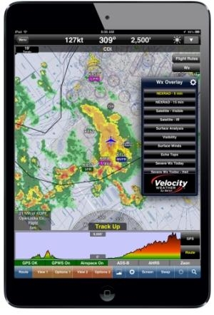
Hilton Software LLC has rolled out the latest version of WingX Pro7. Version 7.0 delivers the ability to graphically visualize both real-time and predictive weather information from Baron Services in a highly customizable interactive map.

WingX Pro7 adds the ability to view a route line and breadcrumb trail on approach charts and to view pitot-static information on its moving map when using Levil’s innovative iLevil AW. Version 7.0 continues to enhance and expand support for Civil Air Patrol and Coast Guard pilots with enhanced auto lat/lon capabilities to complement its comprehensive grid and search pattern support.

WingX Pro7’s improvements also include simplified Favorites and Altitude Calibration--particularly useful when using either GPS Altitude or Pressure Altitude.

In addition, Version 7.0 seamlessly integrates Baron Service’s advanced weather with its award winning moving map. This weather information is tailored to the pilot’s planning and flying conditions enabling improved decision making. By using a simple settings pop-up, pilots can change the weather transparency, change the animation rate, and even change the weather resolution to reduce download bandwidth requirements-- perfect for pilots at remote airports or using a hotel’s slow network connection.

WingX Pro7 offers an impressive selection of Baron’s industry-leading weather information which includes NEXRAD, Visible and IR Satellite, Echo Tops, Surface Analysis, and Contoured Surface Wind Speed just to name a few. "Pilots deserve the most advanced aviation technology and weather graphics at their fingertips,” said Dr. Goldstein, founder of Hilton Software LLC. “By working closely with Baron Services, we have combined two best-of-breed products to create an unbelievable aviation platform.”

Version 7.0 gives pilots the ability to view their route and breadcrumb trail on approach charts. Pilots can add waypoints and fixes using ChartTouch directly on the approach chart and see their route line updated immediately on the approach chart thereby reducing workload and simplifying instrument flying.

WingX Pro7 was the first major iPad app with ADS-B Weather and Traffic support. WingX Pro7 further expanded its external hardware capabilities by adding support for many more ADS-B receivers as well as AHRS and PCAS traffic systems. With Version 7.0, WingX Pro7 becomes the first major iPad app to add pitot-static support for the experimental market. “WingX Pro7's support for the iLevil AW has a significant impact on the role of tablets in Experimental Aviation today,” says Ruben Leon, founder of Levil Technology and EAA enthusiast. “The two systems combined offer everything I could ever dream of as an experimental pilot and I have never felt safer and more proud when flying my RV9.”

The update is available immediately for download in the Apple App Store and is a free update for existing customers.

FMI: www.hiltonsoftware.com

Advertisement

More News

Airborne 07.21.25: Nighthawk!, Hartzell Expands, Deltahawk 350HP!

Also: New Lakeland Fly-in!, Gleim's DPE, MOSAIC! Nearly three-quarters of a century in the making, EAA is excited about the future… especially with the potential of a MOSAIC>[...]

ANN's Daily Aero-Term (07.27.25): Estimated (EST)

Estimated (EST) -When used in NOTAMs “EST” is a contraction that is used by the issuing authority only when the condition is expected to return to service prior to the >[...]

ANN's Daily Aero-Linx (07.27.25)

Aero Linx: Regional Airline Association (RAA) Regional airlines provide critical links connecting communities throughout North America to the national and international air transpo>[...]

NTSB Final Report: Luce Buttercup

The Airplane Broke Up In Flight And Descended To The Ground. The Debris Path Extended For About 1,435 Ft. Analysis: The pilot, who was the owner and builder of the experimental, am>[...]

Classic Aero-TV: 'That's All Brother'-Restoring a True Piece of Military History

From 2015 (YouTube version): History Comes Alive Thanks to A Magnificent CAF Effort The story of the Douglas C-47 named, “That’s all Brother,” is fascinating from>[...]

blog comments powered by Disqus


Advertisement

Advertisement

Podcasts

Advertisement

© 2007 - 2025 Web Development & Design by Pauli Systems, LC