Wed, Oct 24, 2007
Aircraft Equipped With Thermal Imaging Sensors
In response to a request from the California Office of Emergency
Services and the National Interagency Fire Center, NASA is flying
an aircraft equipped with sophisticated infrared imaging equipment
Wednesday to assist firefighters battling several of the Southern
California wildfires.
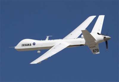
The Ikhana unmanned aircraft system, a Predator B modified for
civil science and research missions, was launched about 0845 PDT
from its base at NASA's Dryden Flight Research Center at Edwards
Air Force Base. It is expected to fly over the major blazes burning
in the Lake Arrowhead and Running Springs areas and possibly down
into San Diego County to image wildfires raging in that area. The
aircraft is controlled remotely by pilots in a ground control
station at NASA Dryden.
The Ikhana is carrying the Autonomous Modular Scanner, a
thermal-infrared imaging system developed at NASA's Ames Research
Center in Northern California. The system is capable of peering
through heavy smoke and darkness to see hot spots, flames and
temperature differences, processing the imagery on-board, and then
transmitting that information in near real time so it can aid fire
incident commanders in allocating their firefighting resources.
The images are transmitted through a communications satellite to
NASA Ames where the imagery is placed on an Ames Web site, combined
with Google Earth maps, and then transmitted to the interagency
fire center in Boise, ID where it is then made available to
incident commanders in the field.
As ANN reported, the Ikhana
system was validated recently during a series of wildfire imaging
demonstration missions conducted by NASA and the US Forest Service
in August and September.

Mission managers indicated a second imaging flight may occur on
Thursday, October 25, as well. Each flight is being coordinated
with the FAA to allow the remotely piloted aircraft to fly within
the national airspace while maintaining separation from other
aircraft.
More News
Pilot Also Reported That Due To A Fuel Leak, The Auxiliary Fuel Tanks Were Not Used On June 4, 2025, at 13:41 eastern daylight time, a Piper PA-23, N2109P, was substantially damage>[...]
Have A Story That NEEDS To Be Featured On Aero-News? Here’s How To Submit A Story To Our Team Some of the greatest new stories ANN has ever covered have been submitted by our>[...]
From 2023 (YouTube Edition): Reflections on War’s Collective Lessons and Cyclical Nature The exigencies of war ought be colorblind. Inane social-constructs the likes of racis>[...]
Aero Linx: Colorado Pilots Association (CPA) Colorado Pilots Association was incorporated as a Colorado Nonprofit Corporation in 1972. It is a statewide organization with over 700 >[...]
High Speed Taxiway A long radius taxiway designed and provided with lighting or marking to define the path of aircraft, traveling at high speed (up to 60 knots), from the runway ce>[...]
 NTSB Prelim: Piper PA-23

