Full-Size Unmanned Helicopter Avoids Terrain, Evaluates Landing
Sites, Generates Approach Paths
Autonomous flight at low altitude and landing zone
evaluation/selection using a full-size unmanned helicopter were
recently demonstrated by a team from Piasecki Aircraft and Carnegie
Mellon University. The team developed and flight demonstrated a
navigation/sensor system that enables full-size, autonomous
helicopters to fly at low altitude while avoiding obstacles;
evaluate and select suitable landing sites in unmapped terrain; and
land safely using a self-generated approach path.
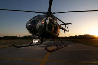
Little Bird Test Platform
The technology has been developed to allow future unmanned
helicopters to evacuate wounded soldiers from contaminated or
live-fire battlefields and to resupply forward military bases. It
is also applicable as a pilot aid to help both military and
civilian pilots avoid obstacles, such as power lines, and select
landing sites in unimproved areas such as emergency scenes, even
when operating in low-light or low-visibility conditions.
In mid-June, the Piasecki/Carnegie Mellon team flight tested the
navigation/sensor system at The Boeing Company’s Rotorcraft
Systems facility in Mesa, AZ, using the Unmanned Little Bird
helicopter test bed. The Piasecki/Carnegie Mellon sensor package
and navigation, mapping and collision avoidance software repeatedly
demonstrated the ability to land in cluttered environments. In each
case, the navigation/sensor system had to map an unknown area where
large and small obstructions limited the possible landing sites
– circumstances typical of a military or civilian medical
evacuation mission. The system was able to reliably identify level
landing sites with clear approach paths that were accessible for
evacuating a simulated casualty. The system also was able to detect
and maneuver around a manlift extended to a height of 60 feet while
flying at a speed of more than 20 knots. Flight tests also
demonstrated the sensor package was able to detect high-tension
wires over desert terrain.
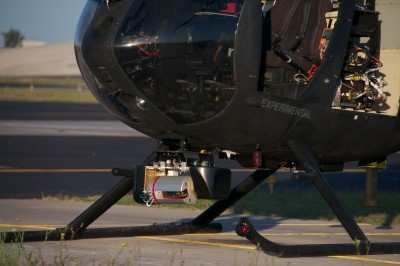
Sensor Package Close-Up View
The demonstration was the culmination of work sponsored by the
U.S. Army’s Telemedicine and Advanced Technology Research
Center (TATRC) through a Small Business Innovation Research (SBIR)
program with Piasecki Aircraft and Carnegie Mellon’s Robotics
Institute, supplemented with significant additional funding from
Piasecki.
Currently, unmanned helicopters can only fly autonomously
in mapped areas known to be free of obstructions. The new sensing
and navigation capability demonstrated under this project will make
unmanned helicopters far more useful and safer allowing them to
operate in the near earth obstacle rich environment, where only
manned helicopters have traditionally been able to fly at great
risk.
The Piasecki/Carnegie Mellon team developed a sensor package
that includes inertial sensing and an advanced laser scanner that
can look forward or down, depending on flight parameters. Paired
with mapping and obstacle avoidance software, these sensors build
3-D maps of the ground and find obstacles in the aircraft’s
path. In the tests at the Mesa facility, the sensors demonstrated
that they could detect four-inch-high pallets, chain link fences,
vegetation, people and other objects that could block a potential
landing site. The laser scanner is effective even when dust
obscures the landing site, as often occurs during operations in
desert terrain.
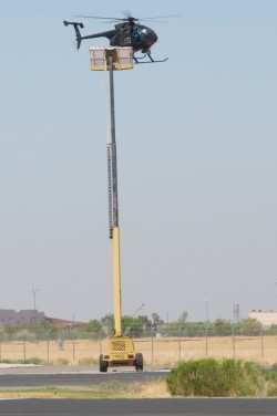
Obstacle Avoidance Demonstration
Navigation and planning software developed at Carnegie Mellon
for use in robotic ground vehicles was adapted for use in the air,
enabling the helicopter to continuously identify potential landing
sites and develop possible landing approaches and abort paths. The
system is programmed to select a safe landing site that is closest
to a given set of coordinates, such as the location of a casualty
or a drop-off point for resupply. The software keeps a running rank
of the possible landing sites and approach/abort paths, enabling
the aircraft to respond rapidly to unexpected developments on the
ground and in the air.
“Operation at low altitudes is where helicopters are most
valuable, but also where they are most vulnerable,” said
Sanjiv Singh, Research Professor in Carnegie Mellon’s
Robotics Institute. “Demonstrating that a full-scale robotic
helicopter can safely takeoff, fly at low altitude and land heralds
a new era when we can significantly reduce risk, either by giving a
pilot new aids for avoiding mishaps or by eliminating the pilot
entirely.”

Most previous research projects involving low altitude flight by
robotic helicopters have used small aircraft, which have different
flying characteristics than a man-capable craft such as the
10-meter-long ULB. Singh said the performance of the
sensor/navigation package on the full-scale ULB indicates that
scaling it to even larger craft will pose no problem.
The Government Project lead for this effort is Dr. Gary Gilbert,
TATRC. The Piasecki/Carnegie Mellon team was lead by Fred Piasecki,
Principal Investigator and Dr. Sanjiv Singh from Carnegie Mellon.
Team members include Lyle Chamberlain, Lead Test Engineer,
Sebastian Scherer, Software Lead, Jim Cline, Airframe Integration
Design Lead, Brian Geiger, Project Engineer, and Buzz Miller,
Project Coordinator.
 ANN's Daily Aero-Linx (05.06.25)

