Lockheed Martin Flies First 360-Degree Infrared Sensor On Small UAS | Aero-News Network
Aero-News Network
RSS icon RSS feed
podcast icon MP3 podcast
Subscribe Aero-News e-mail Newsletter Subscribe

Airborne Unlimited -- Most Recent Daily Episodes

Episode Date

Airborne-Monday

Airborne-Tuesday

Airborne-Wednesday Airborne-Thursday

Airborne-Friday

Airborne On YouTube

Airborne-Unlimited-05.19.25

Airborne-NextGen-05.20.25

AirborneUnlimited-05.21.25

Airborne-AffordableFlyers-05.22.25

AirborneUnlimited-05.23.25

Fri, Oct 09, 2009

Lockheed Martin Flies First 360-Degree Infrared Sensor On Small UAS

One Of Five "Snap-On" Payloads For Hand-Launched UAS

Lockheed Martin says it recently completed a successful test of a new infrared sensor turret aboard its Desert Hawk III Unmanned Aircraft System (UAS), marking the first time a small UAS has flown with a 360-degree infrared sensor.

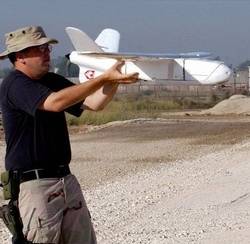
Battle-proven, the hand-launched Desert Hawk III has provided the British Army with critical Intelligence, Surveillance and Reconnaissance (ISR) capabilities in both Iraq and Afghanistan. The small UAS (54-inch wingspan) is specifically designed to operate at high altitudes, in high winds and extreme temperatures.

File Photo

Successful flight tests of the Desert Hawk III's new payload offering, held September 23- 24 at the Minnesota National Guard's Camp Ripley unmanned vehicle proving grounds, validate the UAS's ability to greatly improve nighttime ISR for ground forces. By providing 360-degree infrared coverage, troops obtain greater target location accuracy and superior image stability. Combined with an upgraded 360-degree color Electro Optic (E/O) sensor, operators gained 10 times continuous zoom capability, significantly aiding in contact identification.


"To assist the warfighter, we have miniaturized the infrared payload, so it fits into a turret weighing less than two pounds," said John Nikolai, director of electronic products & logistics at Lockheed Martin's Tactical Systems business in Eagan, MN. "The E/O camera has been upgraded as well, for improved target identification. With the introduction of these sensor capabilities, users will experience vastly improved nighttime situational awareness."

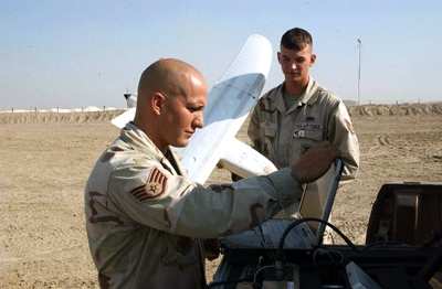
File Photo

Lockheed Martin's Desert Hawk III features an open architecture environment and consists of a lightweight, hand-launched, ruggedized air vehicle with snap-on Plug and Playloads, a portable ground station and a remote video terminal. The snap-on payload capability allows a single operator to swap sensors on the air vehicle in less than one minute to meet immediate and rapidly changing mission requirements.

Currently, the Desert Hawk III offers five modular capability payloads for mission flexibility. The payloads include a 360-degree turret with a mix of E/O and/or black and white low-light imagers, an infrared stabilized imager in a roll axis out to 90 degrees, a signals intelligence sensor, the new 360-degree infrared sensor and the upgraded 360-degree E/O imager with continuous zoom.

FMI: www.lockheedmartin.com

Advertisement

More News

Oshkosh Memories: An Aero-News Stringer Perspective

From 2021: The Inside Skinny On What Being An ANN Oshkosh Stringer Is All About By ANN Senior Stringer Extraordinare, Gene Yarbrough The annual gathering at Oshkosh is a right of p>[...]

NTSB Prelim: Piper PA32RT

Video Showed That During The Takeoff, The Nose Baggage Door Was Open On May 10, 2025, about 0935 eastern daylight time, a Piper PA-32RT-300, N30689, was destroyed when it was invol>[...]

ANN FAQ: Follow Us On Instagram!

Get The Latest in Aviation News NOW on Instagram Are you on Instagram yet? It's been around for a few years, quietly picking up traction mostly thanks to everybody's new obsession >[...]

Aero-News: Quote of the Day (05.28.25)

"I think what is key, we have offered a bonus to air traffic controllers who are eligible to retire. We are going to pay them a 20% bonus on their salary to stay longer. Don't reti>[...]

ANN's Daily Aero-Term (05.28.25): Pilot Briefing

Aero Linx: Pilot Briefing The gathering, translation, interpretation, and summarization of weather and aeronautical information into a form usable by the pilot or flight supervisor>[...]

blog comments powered by Disqus


Advertisement

Advertisement

Podcasts

Advertisement

© 2007 - 2025 Web Development & Design by Pauli Systems, LC