WY TFR: 06.22.08 - 06.23.08 | Aero-News Network
Aero-News Network
RSS icon RSS feed
podcast icon MP3 podcast
Subscribe Aero-News e-mail Newsletter Subscribe

Airborne Unlimited -- Most Recent Daily Episodes

Episode Date

Airborne-Monday

Airborne-Tuesday

Airborne-Wednesday Airborne-Thursday

Airborne-Friday

Airborne On YouTube

Airborne-Unlimited-11.17.25

AirborneNextGen-
11.11.25

Airborne-Unlimited-11.12.25

Airborne-FltTraining-11.13.25

AirborneUnlimited-11.14.25

LIVE MOSAIC Town Hall (Archived): www.airborne-live.net

Fri, Jun 20, 2008

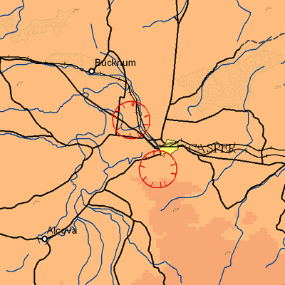
WY TFR: 06.22.08 - 06.23.08

NOTAM Number: FDC 8/3216
Issue Date: June 18, 2008 at 2306 UTC
Location: Casper, Wyoming
Beginning Date and Time: June 22, 2008 at 1935 UTC
Ending Date and Time: June 22, 2008 at 2230 UTC Reason for NOTAM: Temporary flight restrictions for VIP (Very Important Person) Movement
Type: VIP
Replaced NOTAM(s): N/A

Affected Area(s)

Area A
Airspace Definition:
 Center: On the MUDDY MOUNTAIN VORTAC (DDY) 205 degree radial at 13.7 nautical miles. (Latitude: 42º54'29"N, Longitude: 106º27'51"W)
 Radius: 3 nautical miles
 Altitude: From the surface up to but not including 3000 feet AGL
Effective Date(s):
 From June 22, 2008 at 1935 UTC (June 22, 2008 at 1335 MDT)
 To June 22, 2008 at 2025 UTC (June 22, 2008 at 1425 MDT)

Area B
Airspace Definition: 
 Center: On the MUDDY MOUNTAIN VORTAC (DDY) 178 degree radial at 18.5 nautical miles. (Latitude: 42º47'09"N, Longitude: 106º20'48"W)
 Radius: 3 nautical miles
 Altitude: From the surface up to but not including 3000 feet AGL
Effective Date(s):
 From June 22, 2008 at 2015 UTC (June 22, 2008 at 1415 MDT)
 To June 22, 2008 at 2155 UTC (June 22, 2008 at 1555 MDT)

Area C
Airspace Definition: 
 Center: On the MUDDY MOUNTAIN VORTAC (DDY) 205 degree radial at 13.7 nautical miles. (Latitude: 42º54'29"N, Longitude: 106º27'51"W)
 Radius: 3 nautical miles
 Altitude: From the surface up to but not including 3000 feet AGL
Effective Date(s):
 From June 22, 2008 at 2145 UTC (June 22, 2008 at 1545 MDT)
 To June 22, 2008 at 2230 UTC (June 22, 2008 at 1630 MDT)

Operating Restrictions and Requirements

No pilots may operate an aircraft in the areas covered by this NOTAM (except as described).

Unless otherwise authorized by ATC.

Other Information:

ARTCC: ZDV - Denver Center
Authority: Title 14 CFR section 91.141

FMI: www.tfr.faa.gov, Depicted TFR data may not be a complete listing. Pilots should not use the information on this website for flight planning purposes. For the latest information, call your local Flight Service Station at 1-800-WX-BRIEF.


Advertisement

More News

Aero-News: Quote of the Day (11.17.25)

“We achieved full mission success today, and I am so proud of the team. It turns out Never Tell Me The Odds had perfect odds—never before in history has a booster this >[...]

ANN's Daily Aero-Term (11.17.25): NonDirectional Beacon

NonDirectional Beacon An L/MF or UHF radio beacon transmitting nondirectional signals whereby the pilot of an aircraft equipped with direction finding equipment can determine his/h>[...]

NTSB Final Report: Fred L Wellman CH 750 Cruzer

About 5ft Above Ground Level, The Airplane Stalled, And The Left Wing Dropped Analysis: The pilot reported that this flight was conducted as part of phase 1 flight testing of the n>[...]

ANN's Daily Aero-Linx (11.17.25)

Aero Linx: Brodhead Pietenpol Association The Brodhead Pietenpol Association is a newly reorganized (in 2017) non-profit educational corporation that grew and developed from an ear>[...]

Airborne-NextGen 11.11.25: Archer Buys Hawthorne, Joby Conforms, Stranded Astros

Also: VerdeGo Contract, Medi-Carrier, Gambit 6 UCAV, Blade Urban Air Mobility Pilot Archer Aviation has inked a deal for control of Hawthorne Municipal Airport (HHR), also known as>[...]

blog comments powered by Disqus


Advertisement

Advertisement

Podcasts

Advertisement

© 2007 - 2025 Web Development & Design by Pauli Systems, LC