Wed, Sep 12, 2012
Storm Expected To Strengthen Into A Tropical Storm Soon
NASA's Hurricane and Severe Storm Sentinel (HS3) airborne mission sent an unmanned Global Hawk aircraft Tuesday morning to study newborn Tropical Depression 14 in the central Atlantic Ocean that seems primed for further development. The Global Hawk left NASA's Wallops Flight Facility on Wallops Island, VA, for a planned 26-hour flight to investigate the depression.
NASA's latest hurricane science field campaign began on September 7 when the Global Hawk flew over Hurricane Leslie in the Atlantic Ocean. HS3 marks the first time NASA is flying Global Hawks from the U.S. East Coast. According to Chris Naftel, project manager of NASA's Global Hawk program at NASA's Dryden Flight Research Center, Edwards Air Base, CA, the Global Hawk aircraft took off at 0706 EDT and headed for Tropical Depression 14, which at the time of take-off, was still a developing low pressure area called System 91L.
At 1100 EDT, Tropical Depression 14 was located near 16.3 North latitude and 43.1 West longitude, about 1,210 miles east of the Lesser Antilles. The depression had maximum sustained winds near 35 mph. It was moving to the west near 10 mph and had a minimum central pressure of 1006 millibars. The National Hurricane Center expects Tropical Depression 14 to strengthen into a tropical storm over the next 24 hours, and turn to the northwest.
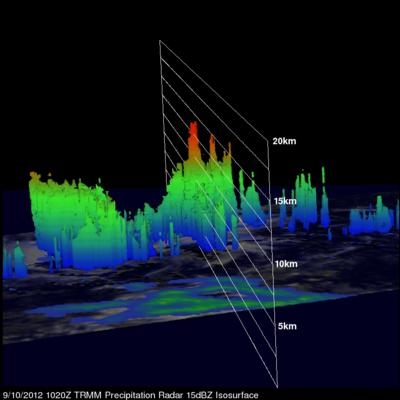
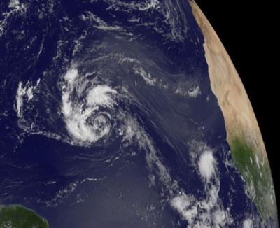
On Sept. 10, the Tropical Rainfall Measuring Mission (TRMM) satellite passed over Tropical Depression 14, when it was known as low pressure System 91L and data from TRMM's Microwave Imager (TMI) and Precipitation Radar (PR) were used to create a rainfall analysis. The data was overlaid on a combination infrared and visible image from TRMM's Visible and InfraRed Scanner (VIRS) and showed that System 91L was getting organized and that convective storms reaching heights of about 8.1 miles were dropping heavy rain to the northwest and northeast of the center of the circulation.
The HS3 mission targets the processes that underlie hurricane formation and intensity change. The data collected will help scientists decipher the relative roles of the large-scale environment and internal storm processes that shape these systems.
(Images provided by NASA Top: GOES Satellite image, Bottom: TRMM Satellite image)
More News
Terminal Radar Service Area Airspace surrounding designated airports wherein ATC provides radar vectoring, sequencing, and separation on a full-time basis for all IFR and participa>[...]
Very High Frequency (VHF) The frequency band between 30 and 300 MHz. Portions of this band, 108 to 118 MHz, are used for certain NAVAIDs; 118 to 136 MHz are used for civil air/grou>[...]
“From approximately November 2021 through January 2022, Britton-Harr, acting on behalf of AeroVanti, entered into lease-purchase agreements for five Piaggio-manufactured airc>[...]
Also: Virtual FLRAA Prototype, IFR-Capable Autonomous A/C, NS-32 Crew, Golden Dome Missile Defense Bombardier announced that the first production Global 8000 successfully completed>[...]
Aero Linx: The 1-26 Association (Schweizer) The Association’s goal is to foster the helpfulness, the camaraderie, and the opportunity for head-to-head competition that is fou>[...]
 ANN's Daily Aero-Term (05.29.25): Terminal Radar Service Area