NASA Langley Energy Budget Instrument To Launch Aboard NOAA Satellite | Aero-News Network
Aero-News Network
RSS icon RSS feed
podcast icon MP3 podcast
Subscribe Aero-News e-mail Newsletter Subscribe

Airborne Unlimited -- Most Recent Daily Episodes

Episode Date

Airborne-Monday

Airborne-Tuesday

Airborne-Wednesday Airborne-Thursday

Airborne-Friday

Airborne On YouTube

Airborne-Unlimited-05.19.25

Airborne-NextGen-05.20.25

AirborneUnlimited-05.21.25

Airborne-AffordableFlyers-05.22.25

AirborneUnlimited-05.23.25

Tue, Oct 31, 2017

NASA Langley Energy Budget Instrument To Launch Aboard NOAA Satellite

The Last In A Series Of Instruments That Measure The Solar Energy Reflected By Earth And Other Parameters Will Launch To Orbit Next Month

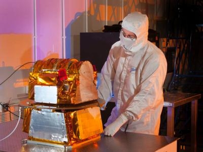
The Clouds and the Earth's Radiant Energy System Flight Model 6 (CERES FM6), developed by Northrop Grumman and managed by NASA's Langley Research Center in Hampton, Virginia, is scheduled to launch Nov. 10 aboard the National Oceanic and Atmospheric Administration's Joint Polar Satellite System-1 (JPSS-1) from Vandenberg Air Force Base in California.

Liftoff aboard a United Launch Alliance Delta II rocket from Space Launch Complex 2W is targeted for 1:47 a.m. PST (4:47 a.m. EST) at the opening of a 65-second launch window. JPSS, a collaborative effort between NOAA and NASA, represents significant technological and scientific advancements in observations used for severe weather prediction and environmental monitoring.

"CERES provides critical observations of how solar energy absorbed and terrestrial infrared radiative energy emitted by Earth are distributed over the planet, thereby helping to improve seasonal weather and long-term climate predictions," said Norman Loeb, principal investigator for NASA's Radiation Budget Science Project. "CERES FM6 will extend the existing CERES record, helping to quantify decadal changes in Earth's energy budget and clouds, and improve our understanding of the mechanisms that drive those changes."

Global CERES data allow scientists to validate models that calculate the effect of clouds on planetary heating or cooling. Those data also help improve seasonal climate forecasts, including cloud and radiative aspects of large-scale climate events like El Niño and La Niña. In addition, CERES data can be used for assessing the radiative effects and climatic impact of natural disasters like volcanic eruptions, major floods and droughts.

For 32 years, Langley instruments have provided stewardship of critical climate observations both through CERES and the Earth Radiation Budget Experiment (ERBE), which began measurements in 1984.

Five CERES instruments already are on orbit aboard three satellites. CERES FM1 and FM2 launched in 1999 on the Terra satellite. CERES FM3 and FM4 launched in 2002 on the Aqua satellite. CERES FM5 launched in 2011 on the Suomi NPP satellite. A CERES instrument that launched on the TRMM satellite in 1997 stopped collecting data in 2000.

"This final instrument from a program that has spanned more than 20 years represents the culmination of a long and fruitful partnership with Northrop Grumman in designing, building, and operating the CERES instruments," said CERES Project Scientist Kory Priestley. "We fully expect the FM-6 instrument to function as well as its predecessors, providing critical observations that benefit humanity for another 10 to 15 years."

(Image provided with NASA news release)

FMI: eospso.gsfc.nasa.gov/sites/default/files/publications/CERES%20Mission%20Brochure%20508.pdf

Advertisement

More News

NTSB Prelim: Lee Aviation LLC JA30 SuperStol

A Puff Of Smoke Came Out From The Top Of The Engine Cowling Followed By A Total Loss Of Engine Power On May 9, 2025, about 1020 mountain daylight time, an experimental amateur-buil>[...]

Classic Aero-TV: Curtiss Jenny Build Wows AirVenture Crowds

From 2022 (YouTube Edition): Jenny, I’ve Got Your Number... Among the magnificent antique aircraft on display at EAA’s AirVenture 2022 was a 1918 Curtiss Jenny painstak>[...]

ANN's Daily Aero-Term (05.30.25): Very High Frequency (VHF)

Very High Frequency (VHF) The frequency band between 30 and 300 MHz. Portions of this band, 108 to 118 MHz, are used for certain NAVAIDs; 118 to 136 MHz are used for civil air/grou>[...]

Aero-News: Quote of the Day (05.30.25)

“From approximately November 2021 through January 2022, Britton-Harr, acting on behalf of AeroVanti, entered into lease-purchase agreements for five Piaggio-manufactured airc>[...]

Classic Aero-TV: Quest Kodiak Enhances Migration Monitoring Programs

From 2008 (YouTube Edition): US Fish and Wildlife Service Chooses The Kodiak To Monitor Waterfowl Populations Waterfowl all over North America may soon have to get used to a new ab>[...]

blog comments powered by Disqus


Advertisement

Advertisement

Podcasts

Advertisement

© 2007 - 2025 Web Development & Design by Pauli Systems, LC