Mon, Dec 24, 2012
More Than 1,500 Airports Have Published Precision Approaches
Pilots flying all types of aircraft are now able to reach more runways in low visibility conditions than ever before. The FAA says that last month, the Wide Area Augmentation System (WAAS) program exceeded 3,000 Localizer Performance with Vertical guidance (LPVs) approaches published. This is significant because of the safety and capacity benefits of WAAS-enabled approaches.
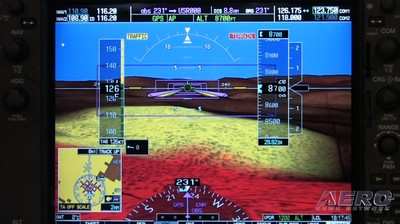
WAAS now provides vertically-guided approach capability at more than 1,500 airports, bringing aircraft to as low as 200 feet above the runway surface. Some airports do not qualify for LPVs because of obstructions or terrain. In those cases, the FAA is providing WAAS Localizer Performance (LP) procedures.
WAAS makes it possible for pilots to use GPS from takeoff through the equivalent of a Category I Instrument Landing Systems (ILS) approach. More than 60,000 aircraft are certified to use WAAS, which means they are capable of using Performance Based Navigation (PBN), a key component for the FAA’s Next Generation Air Transportation System (NextGen). The use of PBN frees aircraft from the old highways in the sky that are dependent on ground-based beacons, allowing for more direct and fuel-efficient routes. It also provides options for avoiding bad weather or unexpected air traffic congestion.
Since becoming operational in 2003, WAAS has made remarkable progress. With the consistent development of LPVs and LPs, WAAS will continue to enhance safety and enable pilots to fly into places that would have been unavailable nine years ago.
The WAAS program reached another major milestone this year when the FAA awarded the WAAS Geostationary Earth Orbit GEO Satellite Service Lease contract to Raytheon Company of Fullerton, Calif. Geostationary satellites provide better broadcast coverage throughout the United States.
WAAS uses three GEO satellites to broadcast the WAAS signal to users across North America. Three satellites are required to maintain WAAS availability. The current GEO satellite leased services expire between 2015 and 2017. These new WAAS GEO satellites will enable the FAA to sustain the WAAS GEO satellite constellation maintaining high availability of service to users.
More News
Check out Blackshape in Oshkosh Display #190 Situated in the Apulian Aerospace district in Monopoli, Italy, Blackshape embodies the epitome of Italian craftsmanship, style, and qua>[...]
A Powerhouse In Aviation Safety Technology, Visit Alpha Systems AOA at Osh Display#3124-3125 Alpha systems AOA has been developing and integrating Angle of Attack systems for the l>[...]
Pilot Noticed That The No. 2 Engine Torque Indicator Was “Maxed Out” And The No. 1 Torque Indicator Was About 60% Analysis: The pilot in command (PIC) reported that the>[...]
Decision Altitude (DA) A specified altitude (mean sea level (MSL)) on an instrument approach procedure (ILS, GLS, vertically guided RNAV) at which the pilot must decide whether to >[...]
Aero Linx: HeliOffshore HeliOffshore is the global, safety-focused association for the offshore helicopter industry. Our mission is to lead a collective safety conversation, identi>[...]
 ANN Thanks Our Speedy Sponsor... Blackshape!!!