Will Measure Wind And Temperature Profiles For Atmospheric Research
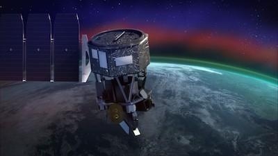
A U.S. Naval Research Laboratory (NRL) instrument aboard NASA’s Ionospheric Connection Explorer (ICON) satellite will deliver unprecedented information to help scientists investigate how both terrestrial and solar weather impact the ionosphere, the ionized region of Earth’s upper atmosphere. ICON launched from Cape Canaveral, Florida, Oct. 10.
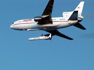
A Northrop Grumman Stargazer L-1011 aircraft took off at 8:31 p.m. EDT from Cape Canaveral Air Force Station in Florida carrying ICON, on a Northrop Grumman Pegasus XL rocket, to launch altitude of about 39,000 feet. The first launch opportunity around 9:30 was skipped due to communication issues between the ground team at Cape Canaveral and the aircraft. On the second attempt, the aircraft crew released its payload at 9:59 p.m. EDT and automated systems on the Pegasus rocket launched ICON, a spacecraft roughly the size of a refrigerator, into space.
The spacecraft’s solar panels successfully deployed, indicating it has power with all systems operating. After an approximately month-long commissioning period, ICON will begin sending back its first science data in November.
NRL’s MIGHTI (Michelson Interferometer for Global High-Resolution Thermospheric Imaging) will measure wind and temperature profiles and contribute to a critical data set for scientists as they study how energy and dynamics from the lower atmosphere propagate into the space environment.
From its large day-to-day variability to extreme conditions during solar-driven magnetic storms, the ionosphere governs how radio waves propagate and can lead to severe disruptions of radio communications and GPS signals for both the public and the military. Radio signals travel through the ionosphere, or they reflect off the ionosphere to make them reach past Earth’s horizon for the purposes of communication and long-range radar.
“The ionosphere is where Earth ends or where space begins, and we haven’t studied it nearly enough to fully understand how it works and to make reliable predictions,” said Christoph Englert, lead investigator for MIGHTI.
The ionosphere, which overlaps the atmosphere’s mesosphere, thermosphere and exosphere layers, remains somewhat of a mystery to scientists. This border separating Earth from space lies between 30 and 600 miles above the Earth’s surface and is too high for science balloons to reach, and large parts of the region are too low for traditional satellites to fly in.
That’s why NASA wants to explore it from the inside with the ICON satellite, traveling within the ionosphere at an orbit about 350 miles above the Earth’s surface. As one of four scientific instruments aboard the ICON satellite, MIGHTI’s observations will give scientists a better understanding of how weather from the Earth and Sun affect the motion and structure of the neutral and ionized upper atmosphere.
“ICON has an important job to do – to help us understand the dynamic space environment near our home,” said Nicola Fox, director for heliophysics at NASA Headquarters in Washington. “ICON will be the first mission to simultaneously track what’s happening in Earth’s upper atmosphere and in space to see how the two interact, causing the kind of changes that can disrupt our communications systems.”
In the years prior to this mission, NRL developed two instruments using similar optical techniques, one for the STS-112 space shuttle mission in 2002 and the other, the SHIMMER instrument, for STPSat-1, launched in 2007. These instruments studied atmospheric chemistry below 60 miles.
MIGHTI is a project developed by NRL in Washington, D.C. and the St. Cloud State University in St. Cloud, Minnesota. The broader collaboration within NRL leveraged the expertise of researchers across multiple Divisions, including Space Science, Spacecraft Engineering, Remote Sensing, Plasma Physics and Marine Meteorology.
(Images provided with U.S. Navy news release and from file)
 ANN FAQ: Contributing To Aero-TV

