NY TFR: 05.26.07 | Aero-News Network
Aero-News Network
RSS icon RSS feed
podcast icon MP3 podcast
Subscribe Aero-News e-mail Newsletter Subscribe

Airborne Unlimited -- Most Recent Daily Episodes

Episode Date

Airborne-Monday

Airborne-Tuesday

Airborne-Wednesday Airborne-Thursday

Airborne-Friday

Airborne On YouTube

Airborne-Unlimited-11.17.25

AirborneNextGen-
11.11.25

Airborne-Unlimited-11.12.25

Airborne-FltTraining-11.13.25

AirborneUnlimited-11.14.25

LIVE MOSAIC Town Hall (Archived): www.airborne-live.net

Thu, May 24, 2007

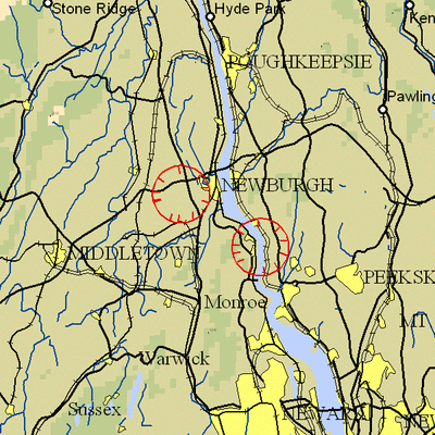
NY TFR: 05.26.07

NOTAM Number: FDC 7/2180
Issue Date: May 23, 2007 at 1335 UTC
Location: West Point, New York
Beginning Date and Time: May 26, 2007 at 1140 UTC
Ending Date and Time: May 26, 2007 at 1550 UTC
Reason for NOTAM: Temporary flight restrictions for VIP (Very Important Person) Movement
Type: VIP
Replaced NOTAM(s): N/A

Affected Area(s)

Area A
Airspace Definition:
 Center: 15.9 nautical miles from KINGSTON VOR/DME(IGN) on the 245 radial (Latitude: 41º30'17"N, Longitude: 74º06'08"W)
 Radius: 3 nautical miles
 Altitude: From the surface up to but not including 3000 feet AGL
Effective Date(s):
 From May 26, 2007 at 1140 UTC (May 26, 2007 at 0740 EDT)
 To May 26, 2007 at 1230 UTC (May 26, 2007 at 0830 EDT)

Area B
Airspace Definition:
 Center: 17.9 nautical miles from CARMEL VOR/DME(CMK) on the 302 radial (Latitude: 41º22'50"N, Longitude: 73º57'15"W)
 Radius: 3 nautical miles
 Altitude: From the surface up to but not including 3000 feet AGL
Effective Date(s):
 From May 26, 2007 at 1220 UTC (May 26, 2007 at 0820 EDT)
 To May 26, 2007 at 1510 UTC (May 26, 2007 at 1110 EDT)

Area C
Airspace Definition:
 Center: 15.9 nautical miles from KINGSTON VOR/DME(IGN) on the 245 radial (Latitude: 41º30'17"N, Longitude: 74º06'08"W)
 Radius: 3 nautical miles
 Altitude: From the surface up to but not including 3000 feet AGL
Effective Date(s):
 From May 26, 2007 at 1500 UTC (May 26, 2007 at 1100 EDT)
 To May 26, 2007 at 1550 UTC (May 26, 2007 at 1150 EDT)

Operating Restrictions and Requirements

No pilots may operate an aircraft in the areas covered by this NOTAM (except as described).

Unless otherwise authorized by ATC.

Other Information:

ARTCC: ZNY - New York Center
Authority: Title 14 CFR section 91.141

FMI: www.tfr.faa.gov, Depicted TFR data may not be a complete listing. Pilots should not use the information on this website for flight planning purposes. For the latest information, call your local Flight Service Station at 1-800-WX-BRIEF.

Advertisement

More News

NTSB Prelim: Funk B85C

According To The Witness, Once The Airplane Landed, It Continued To Roll In A Relatively Straight Line Until It Impacted A Tree In His Front Yard On November 4, 2025, about 12:45 e>[...]

Aero-News: Quote of the Day (11.21.25)

"In the frame-by-frame photos from the surveillance video, the left engine can be seen rotating upward from the wing, and as it detaches from the wing, a fire ignites that engulfs >[...]

ANN's Daily Aero-Term (11.21.25): Radar Required

Radar Required A term displayed on charts and approach plates and included in FDC NOTAMs to alert pilots that segments of either an instrument approach procedure or a route are not>[...]

Classic Aero-TV: ScaleBirds Seeks P-36 Replica Beta Builders

From 2023 (YouTube Edition): It’s a Small World After All… Founded in 2011 by pilot, aircraft designer and builder, and U.S. Air Force veteran Sam Watrous, Uncasville,>[...]

Airborne 11.21.25: NTSB on UPS Accident, Shutdown Protections, Enstrom Update

Also: UFC Buys Tecnams, Emirates B777-9 Buy, Allegiant Pickets, F-22 And MQ-20 The NTSB's preliminary report on the UPS Flight 2976 crash has focused on the left engine pylon's sep>[...]

blog comments powered by Disqus


Advertisement

Advertisement

Podcasts

Advertisement

© 2007 - 2025 Web Development & Design by Pauli Systems, LC