FAA STC Issued For The G500H Helicopter Flight Display | Aero-News Network
Aero-News Network
RSS icon RSS feed
podcast icon MP3 podcast
Subscribe Aero-News e-mail Newsletter Subscribe

Airborne Unlimited -- Most Recent Daily Episodes

Episode Date

Airborne-Monday

Airborne-Tuesday

Airborne-Wednesday Airborne-Thursday

Airborne-Friday

Airborne On YouTube

Airborne-Unlimited-05.05.25

Airborne-NextGen-05.06.25

AirborneUnlimited-05.07.25

Airborne-Unlimited-05.01.25

AirborneUnlimited-05.02.25

Thu, May 27, 2010

FAA STC Issued For The G500H Helicopter Flight Display

All-Glass Panel Optimized For The Rotorcraft Market, Garmin Says

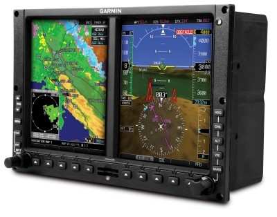
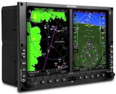
The FAA has granted an STC for the Garmin's G500H, an all-glass avionics system designed specifically for the VFR Part 27 helicopter market. The STC is for the Bell 206-series and Bell 407 helicopters, Garmin announced Thursday.

The GPS maker says the G500H is optimized for the rotorcraft market and it builds upon the best features of the G600 and G500, which are for the fixed-wing aircraft market. The G500H offers capabilities like over 900 SafeTaxi airport diagrams, optional helicopter synthetic vision technology (HSVT), optional XM WX Satellite Weather with NEXRAD, and the option to display video from a forward looking infrared (FLIR) camera or other video sources.

The G500H is available in two versions - one with the PFD on the right, the other version with the PFD on the left. The PFD screen displays attitude, airspeed, vertical speed, altitude and course/heading information, and the MFD shows detailed moving map graphics with the helicopter's current position in relation to terrain, chart data, navaids, and flight plan routings. The G500H communicates and integrates with Garmin's other panel mount products, such as the GNS 430W/530W series.

The G500H is also compatible with Garmin's new GSR 56 Iridium transceiver. This optional worldwide position tracking solution enables aircraft location data to be monitored via web-based displays on authorized base-ops computers.

Customers may interface the G500H with Garmin's TAS and TCAS I traffic systems, the GTS 800, GTS 820 and GTS 850, which are optional equipment. The Garmin traffic systems combine active and passive surveillance data to pinpoint specific traffic threats.

The G500H is available immediately for an expected introductory price of $24,995. The G500H includes the GDU 620 display/control unit, GRS 77H AHRS, GDC 74H digital air data computer, GMU 44 tri-axial magnetometer, and GTP 59 temp probe. Garmin's HSVT is also available immediately as a G500H option for $7,995.

FMI: www.garmin.com/helicopters

Advertisement

More News

ANN's Daily Aero-Linx (05.06.25)

Aero Linx: International Federation of Airworthiness (IFA) We aim to be the most internationally respected independent authority on the subject of Airworthiness. IFA uniquely combi>[...]

ANN's Daily Aero-Term (05.06.25): Ultrahigh Frequency (UHF)

Ultrahigh Frequency (UHF) The frequency band between 300 and 3,000 MHz. The bank of radio frequencies used for military air/ground voice communications. In some instances this may >[...]

ANN FAQ: Q&A 101

A Few Questions AND Answers To Help You Get MORE Out of ANN! 1) I forgot my password. How do I find it? 1) Easy... click here and give us your e-mail address--we'll send it to you >[...]

Classic Aero-TV: Virtual Reality Painting--PPG Leverages Technology for Training

From 2019 (YouTube Edition): Learning To Paint Without Getting Any On Your Hands PPG's Aerospace Coatings Academy is a tool designed to teach everything one needs to know about all>[...]

Airborne 05.02.25: Joby Crewed Milestone, Diamond Club, Canadian Pilot Insurance

Also: Sustainable Aircraft Test Put Aside, More Falcon 9 Ops, Wyoming ANG Rescue, Oreo Cookie Into Orbit Joby Aviation has reason to celebrate, recently completing its first full t>[...]

blog comments powered by Disqus


Advertisement

Advertisement

Podcasts

Advertisement

© 2007 - 2025 Web Development & Design by Pauli Systems, LC