METARmaps Debuts Additional Features | Aero-News Network
Aero-News Network
RSS icon RSS feed
podcast icon MP3 podcast
Subscribe Aero-News e-mail Newsletter Subscribe

Airborne Unlimited -- Most Recent Daily Episodes

Episode Date

Airborne-Monday

Airborne-Tuesday

Airborne-Wednesday Airborne-Thursday

Airborne-Friday

Airborne On YouTube

Airborne-Unlimited-05.05.25

Airborne-NextGen-05.06.25

AirborneUnlimited-05.07.25

Airborne-Unlimited-05.01.25

AirborneUnlimited-05.02.25

Mon, Aug 01, 2022

METARmaps Debuts Additional Features

METARmaps Introduces New Features For 2022

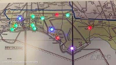
We checked in with Mr. Richard Freilich at EAA AirVenture 2022, and he shared with us that new for this year in version 4.0 of METARmaps are the following features: off-panel processing (the work is being done in the cloud) which will facilitate easier over-the-air (OTA) updates and feature enhancements to the map, geo-dimming (real-time sunrise brightening or sunset dimming), in addition to the lightning indications (via LED flicker), general wind, and sustained wind-gust information (via LED pulse at programmed rates) that was previously available.     

To the uninitiated, the METARmap is an informative piece of wall-art which displays the current aviation weather flight rules (VFR, MVFR, IFR, LIFR) using the same color-coded information (green, blue, red, and pink) you’d typically see in your aviation weather products. It updates the weather information every five minutes through the light emitting diodes (LEDs) collocated with an airport identifier if available. Provided you have an active internet connection, this information is refreshed across your chosen METARmap which is available in sizes/configurations configurations covering the entire USA, a section of the USA, or on a smaller scale terminal area charts (TACs). Presently, this product only illuminates the weather conditions at airports in the USA provided they have a reporting station, and the longest runway is at least 4,000ft.

Previously, the baked-in features of version 3.0 included the use of dedicated micro-processor with compiled firmware on the panel itself, but this new release for version 4.0 does all the work in the cloud which now permits additional features and functionality to be sent directly to the map, on the reboot, as they come available. The maps are alive if power is available, so you’ll need to initiate the reboot yourself. So, if you have suggestions, please reach out to METARmaps and let them know!  They’d love to hear from you.

According to Mr. Freilich, you can begin the addiction around $200 for a METARmini, and expand from there.  The entry-level Terminal Area Charts (TAC’s) aka METARmini, offers the pilot or enthusiast the opportunity to get on the “METARmap wagon” at a relatively cheaper price point, with all the informative features of their larger brethren in the national (single- or triple-panel) USA METARmap. “METARmaps have been embraced across all sectors general aviation pilots, commercial aviation, Fixed Base Operators (FBO’s), Avidyne, ForeFlight, including Air Traffic Controllers, meteorologists, and others,” said Mr. Freilich.

Of course, as an avid hobbyist you can build your own using RaspberryPi unit, but without the additional logic of wind and lightning information. But, but how soon do you expect to get it done? And can you stomach the wait? The turnaround time from order to ship is a matter of weeks, provided you don’t wait until Christmas to order! You can take wait-time to determine where you’ll mount it and whether you need to prepare the space!

FMI: https://metarmaps.com  

Advertisement

More News

ANN's Daily Aero-Term (05.05.25): Circle To Runway (Runway Number)

Circle To Runway (Runway Number) Used by ATC to inform the pilot that he/she must circle to land because the runway in use is other than the runway aligned with the instrument appr>[...]

ANN's Daily Aero-Linx (05.05.25)

Aero Linx: National Aviation Safety Foundation (NASF) The National Aviation Safety Foundation is a support group whose objective is to enhance aviation safety through educational p>[...]

NTSB Prelim: De Havilland DHC-1

At Altitude Of About 250-300 Ft Agl, The Airplane Experienced A Total Loss Of Engine Power On November 6, 2024, at 1600 central standard time, a De Havilland DHC-1, N420TD, was inv>[...]

Classic Aero-TV: The Boeing Dreamliner -- Historic First Flight Coverage

From 2009 (YouTube Edition): Three Hour Flight Was 'Flawless' -- At Least, Until Mother Nature Intervened For anyone who loves the aviation business, this was a VERY good day. Afte>[...]

Airborne-NextGen 05.06.25: AF Uncrewed Fighters, Drones v Planes, Joby Crew Test

Also: AMA Names Tyler Dobbs, More Falcon 9 Ops, Firefly Launch Unsuccessful, Autonomous F-16s The Air Force has begun ground testing a future uncrewed jet design in a milestone tow>[...]

blog comments powered by Disqus


Advertisement

Advertisement

Podcasts

Advertisement

© 2007 - 2025 Web Development & Design by Pauli Systems, LC