Wounded Eagle UAS Uses Drone To Map VA West Los Angeles Medical Center Campus | Aero-News Network
Aero-News Network
RSS icon RSS feed
podcast icon MP3 podcast
Subscribe Aero-News e-mail Newsletter Subscribe

Airborne Unlimited -- Most Recent Daily Episodes

Episode Date

Airborne-Monday

Airborne-Tuesday

Airborne-Wednesday Airborne-Thursday

Airborne-Friday

Airborne On YouTube

Airborne-Unlimited-10.20.25

AirborneNextGen-
10.21.25

Airborne-Unlimited-10.22.25

Airborne-FltTraining-10.23.25

AirborneUnlimited-10.17.25

Tue, Jun 25, 2019

Wounded Eagle UAS Uses Drone To Map VA West Los Angeles Medical Center Campus

Also Created 3D Renderings Of Several Historical Buildings Including The Wadsworth Chapel And Brentwood Theater

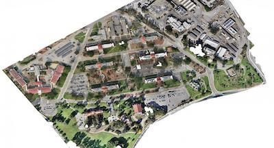
Wounded Eagle (WE) UAS Inc., a veteran run non-profit organization that trains disabled veterans to become experienced and skilled FAA Part 107 UAS operators, has announced that with help from its student UAS operators, it completed aerial mapping of VA Greater Los Angeles Healthcare System's (VAGLAHS) 388-acre VA West Los Angeles Medical Center (WLA) campus.

WE used a UAS and UAS mapping software to capture thousands of images of WLA. The images were stitched together to make a three zone orthomosaic map. WE also created 3D renderings of several historical buildings including the Wadsworth Chapel and Brentwood Theater.

“A truly great opportunity was given to Wounded Eagle UAS by the VA,” says Joseph Dorando, the team lead and remote pilot in charge of UAS operations.

“Our student teams are all disabled veterans and to provide them the capability to learn how to make maps using UAS was a real experience for them and gave them the confidence to do more and go beyond.”

Together, WE and the VAGLAHS Emergency Management Office documented existing facilities and created high-resolution imagery of the entire campus for historical purposes.

The image collections were divided into three zones with the option to merge all three collections together to make one large orthomosaic photogrammetric map of the campus. The resolution is .5 cm per pixel, which allows users to zoom in and view fine details of the buildings such as individual rooftop tiles.

(Image provided with Wounded Eagle news release)

FMI: www.weuas.org

Advertisement

More News

Airborne 10.20.25: FAA Eases On Boeing, Flexjet Lawsuit, Textron Chops eAviation

Also: Global 8000 Records, Cockpit Window Crack Mystery, Daher Brazilian Ops, Senators Push ADS-B/Safety Reviews Boeing has been approved to churn out up to 42 MAX jets per month, >[...]

Airborne-NextGen 10.16.25: Cops Shooting Drones?, Lilium Patents, Trains v UAVs

Also: Sikorsky Intro's U-Hawk, EAA On UAS-BVLOS, Joby Airshow Demo, Hospital Vertiport German regulators are pushing forward a law that would allow police officers to shoot drones >[...]

Airborne 10.17.25: Gryder Airport/Gun Arrest, Hegseth C32 Probs, Hartzell Update

Also: Helicopter Dog Rescue, USDOT Spared In Layoffs, Guardian Avionics, Isaacman Back In Running? The name ’Dan Gryder’ is fairly well known to many in aviation.... Wh>[...]

Classic Aero-TV: ICAS Perspectives - Advice for New Air Show Performers

From 2009 (YouTube Edition): Leading Air Show Performers Give Their Best Advice for Newcomers On December 6th through December 9th, the Paris Las Vegas Hotel hosted over 1,500 air >[...]

Airborne-NextGen 10.21.25: NZ Goes Electric, World Cup UAVs, eAviation Shuttered

Also: SkyFly’s Axe Prototype, USAF CCA, AV Expands Switchblade, DropShip Cargo Drone Air New Zealand has taken its first big step toward electric aviation, flying the US-buil>[...]

blog comments powered by Disqus


Advertisement

Advertisement

Podcasts

Advertisement

© 2007 - 2025 Web Development & Design by Pauli Systems, LC