Modernized GPS Block IIR Sat Ready For Launch | Aero-News Network
Aero-News Network
RSS icon RSS feed
podcast icon MP3 podcast
Subscribe Aero-News e-mail Newsletter Subscribe

Airborne Unlimited -- Most Recent Daily Episodes

Episode Date

Airborne-Monday

Airborne-Tuesday

Airborne-Wednesday Airborne-Thursday

Airborne-Friday

Airborne On YouTube

Airborne-Unlimited-06.10.24

Airborne-NextGen-06.11.24

Airborne-Unlimited-06.12.24 Airborne-FltTraining-06.13.24

Airborne-Unlimited-06.14.24

Tue, Oct 16, 2007

Modernized GPS Block IIR Sat Ready For Launch

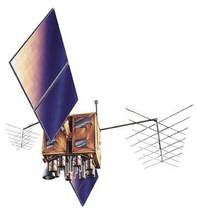
The fourth modernized Global Positioning System (GPS) Block IIR satellite built by Lockheed Martin for the U.S. Air Force is set for launch aboard a Delta II rocket on Oct. 17, from Cape Canaveral Air Force Station, Fla.

The GPS constellation provides critical situational awareness and precision weapon guidance for the military. The worldwide system also supports a wide range of civil, scientific and commercial functions - from air traffic control to the Internet - with precision location and timing information.

"We take great pride in our partnership with the Air Force on this vitally important system," said Don DeGryse, Lockheed Martin's vice president of Navigation Systems, and we look forward to extending our excellent record of delivering advanced navigation capabilities that better serve our warfighters and civil users around the globe."

Lockheed Martin Navigation Systems, Valley Forge, Pa. prime contractor for the GPS IIR program and navigation payload provider ITT of Clifton, N.J. designed and built 21 IIR spacecraft for the Global Positioning Systems Wing, Space and Missile Systems Center, Los Angeles Air Force Base, Calif.

The final eight spacecraft, designated Block IIR-M, were modernized to enhance operations and navigation signal performance for military and civilian GPS users around the globe. Lockheed Martin is also responsible for launch and flight operations support of the GPS IIR and IIR-M satellites.

The Global Positioning System enables properly equipped users to determine precise time and velocity and worldwide latitude, longitude and altitude to within a few meters. Air Force Space Command's 2nd Space Operations Squadron (2SOPS), based at Schriever Air Force Base, Colo., manages and operates the GPS constellation for both civil and military users.

FMI: www.lockheedmartin.com/GPS

Advertisement

More News

ANNouncement: Now Accepting Applications For Oshkosh 2024 Stringers!!!

An Amazing Experience Awaits The Chosen Few... Oshkosh, to us, seems the perfect place to get started on watching aviation recover the past couple of years... and so ANN is putting>[...]

Aero-News: Quote of the Day (06.13.24)

“NBAA has a tremendous responsibility to the business aviation industry, and we are constantly collaborating with them. Our flight departments, professionals and aircraft own>[...]

ANN's Daily Aero-Term (06.13.24): Dead Reckoning

Dead Reckoning Dead reckoning, as applied to flying, is the navigation of an airplane solely by means of computations based on airspeed, course, heading, wind direction, and speed,>[...]

ANN's Daily Aero-Linx (06.13.24)

Aero Linx: Vertical Aviation Safety Team (VAST) We are a public–private initiative to enhance worldwide flight operations safety in all segments of the vertical flight indust>[...]

ANN FAQ: How Do I Become A News Spy?

We're Everywhere... Thanks To You! Even with the vast resources and incredibly far-reaching scope of the Aero-News Network, every now and then a story that should be reported on sl>[...]

blog comments powered by Disqus


Advertisement

Advertisement

Podcasts

Advertisement

© 2007 - 2024 Web Development & Design by Pauli Systems, LC