Sat, Jul 22, 2017
Rockwell Collins Celebrates Four Decades Since Receiving The World's First GPS Satellite Signal
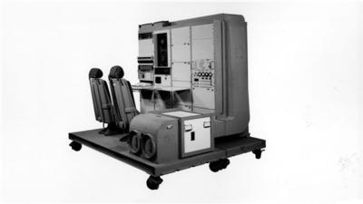
Working well after midnight on a mid-July day in 1977, a Rockwell Collins engineer named David Van Dusseldorp sat on the rooftop of a company building in Cedar Rapids, Iowa, adjusting an antenna every five minutes to receive a signal from the world’s first Global Positioning System (GPS) satellite known as NTS-2. Within a small window of time, the satellite was turned on and the message was successfully received and decoded by the team working the GPS receiver below.
Since then the technology has grown to be the standard of navigation around the world and touches nearly every part of our daily lives. To commemorate the 40 year anniversary, Rockwell Collins invited retirees involved in the project to share their firsthand stories at an event held in Cedar Rapids today.
“We had leaders and team members working together and I knew we could meet the challenge put before us,” said Van Dusseldorp. “The future of GPS was uncertain at the time, but I really felt like we had just accomplished something important.”
Soon after successfully receiving the signal, the U.S. Air Force awarded Rockwell Collins the Navstar GPS user equipment contract. This was the first of many wins that would position the company as a market leader in GPS products for aerospace and defense. Since that time, Rockwell Collins has continued to pioneer advancements in GPS such as being the first to complete a transatlantic flight using GPS navigation in 1983. In 1994, a secure, military-grade Precision Lightweight GPS Receiver (PLGR) was first fielded that provided warfighters a tactical navigational advantage on the battlefield. And in 2014, Rockwell Collins achieved another milestone in navigation technology by successfully developing a prototype to track a satellite in the Galileo Global Navigation Satellite System (GNSS) being created by the European Union to provide global coverage for its nations.
A modern version of the GPS receiver used in 1977 is the Rockwell Collins GPS-4000S, which has the ability to process the transmissions of up to 10 GPS satellites and two Space Based Augmentation Systems (SBAS) geostationary satellites simultaneously. Compared to the first GPS receiver station that was six feet tall, the GPS-4000S receiver is only 7.87 inches tall. Size and power of receivers have evolved for different applications, like the Micro GPS Receiver Application Module (MicroGRAM). The receiver is only one inch tall, can use data from up to 12 GPS satellites and consumes the least power of any receiver in its class. Other advancements in receivers include industry-leading anti-jamming and anti-spoofing technologies that are crucial to security and efficiency when used within critical military and aircraft operations.
(Image provided with Rockwell Collins news release)
More News
Ultrahigh Frequency (UHF) The frequency band between 300 and 3,000 MHz. The bank of radio frequencies used for military air/ground voice communications. In some instances this may >[...]
During The 7 Second Descent, There Was Another TAWS Alert At Which Time The Engine Remained At Full Power On October 24, 2025 at 2115 mountain daylight time, a Cirrus SR22T, N740TS>[...]
From 2009 (YouTube Edition): Educational Organization Aims to Inspire by Sharing Tuskegee Story Founding leader Don Hinz summarized the Red Tail Project’s mission in simple, >[...]
“This feels like an important step since space travel for people with disabilities is still in its very early days... I’m so thankful and hope it inspires a change in m>[...]
Also: New Katanas, Kern County FD Training, IndiGo’s Botched Roster, MGen. Leavitt Named ERAU Dean The Australian Transportation Safety Bureau (ATSB) has wrapped up its inves>[...]
 ANN's Daily Aero-Term (12.19.25): Ultrahigh Frequency (UHF)

