Swirling Spirals At The North Pole Of Mars | Aero-News Network
Aero-News Network
RSS icon RSS feed
podcast icon MP3 podcast
Subscribe Aero-News e-mail Newsletter Subscribe

Airborne Unlimited -- Most Recent Daily Episodes

Episode Date

Airborne-Monday

Airborne-Tuesday

Airborne-Wednesday Airborne-Thursday

Airborne-Friday

Airborne On YouTube

Airborne-Unlimited-05.05.25

Airborne-NextGen-05.06.25

AirborneUnlimited-05.07.25

Airborne-Unlimited-05.01.25

AirborneUnlimited-05.02.25

Sun, Feb 12, 2017

Swirling Spirals At The North Pole Of Mars

Images Captured By ESA's Mars Express

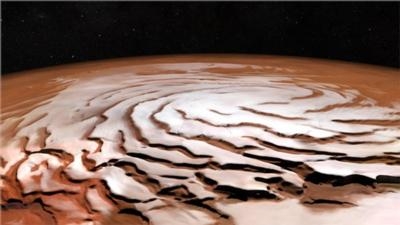
A new mosaic from ESA’s Mars Express shows off the Red Planet’s north polar ice cap and its distinctive dark spiralling troughs.

The mosaic was generated from 32 individual orbit ‘strips’ captured between 2004 and 2010, and covers an area of around a million square kilometres.

The ice cap is a permanent fixture, but in the winter season – as it is now in early 2017 – temperatures are cold enough for around 30 percent of the carbon dioxide in the planet’s atmosphere to precipitate onto the cap, adding a seasonal layer up to a meter thick. During the warmer summer months most of the carbon dioxide ice turns directly into gas and escapes into the atmosphere, leaving behind the water-ice layers.

Strong winds are thought to have played an important role in shaping the ice cap over time, blowing from the elevated centre towards its lower edges and twisted by the same Coriolis force that causes hurricanes to spiral on Earth.

One particularly prominent feature is a 310 mile-long, 1.2 mile-deep trench that almost cuts the cap in two. The plunging canyon, known as Chasma Boreale, is thought to be a relatively old feature, forming before the ice–dust spiral features, and seemingly growing deeper as new ice deposits built up around it.

Subsurface investigations by radar instruments onboard Mars Express and NASA’s Mars Reconnaissance Orbiter revealed that the ice cap is made up of many individual layers of ice and dust extending to a depth of around 2 km.

This presents a valuable record for the nature of how the planet’s climate has changed as its tilt and orbit varied over hundreds of thousands of years.

(Image provided with ESA news release)

FMI: www.esa.int

Advertisement

More News

ANN's Daily Aero-Linx (05.06.25)

Aero Linx: International Federation of Airworthiness (IFA) We aim to be the most internationally respected independent authority on the subject of Airworthiness. IFA uniquely combi>[...]

ANN's Daily Aero-Term (05.06.25): Ultrahigh Frequency (UHF)

Ultrahigh Frequency (UHF) The frequency band between 300 and 3,000 MHz. The bank of radio frequencies used for military air/ground voice communications. In some instances this may >[...]

ANN FAQ: Q&A 101

A Few Questions AND Answers To Help You Get MORE Out of ANN! 1) I forgot my password. How do I find it? 1) Easy... click here and give us your e-mail address--we'll send it to you >[...]

Classic Aero-TV: Virtual Reality Painting--PPG Leverages Technology for Training

From 2019 (YouTube Edition): Learning To Paint Without Getting Any On Your Hands PPG's Aerospace Coatings Academy is a tool designed to teach everything one needs to know about all>[...]

Airborne 05.02.25: Joby Crewed Milestone, Diamond Club, Canadian Pilot Insurance

Also: Sustainable Aircraft Test Put Aside, More Falcon 9 Ops, Wyoming ANG Rescue, Oreo Cookie Into Orbit Joby Aviation has reason to celebrate, recently completing its first full t>[...]

blog comments powered by Disqus


Advertisement

Advertisement

Podcasts

Advertisement

© 2007 - 2025 Web Development & Design by Pauli Systems, LC