Fri, Feb 21, 2014
Updated Version For iOS Devices Incorporates 3D Topographic Landscape To Display
Like a number of their competitors before them, Garmin has announced an updated version of the Garmin Pilot application for the iPad and iPhone featuring synthetic vision as an option for premium subscribers. 3D Vision incorporates GPS-derived airspeed, altitude, and vertical speed overlaid on rich 3D topographic landscape. 3D Vision is transformed when optionally paired with the GDL 39 3D, which superimposes back-up aircraft attitude information overtop the Garmin SVX display.
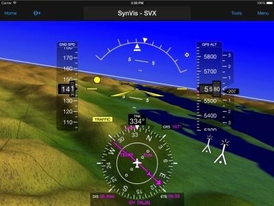
Garmin Pilot incorporates sophisticated graphics modeling to create a virtual topographic landscape. Instead of a blue-over-brown display, pilots will see an in-depth perspective view of realistic terrain features rising into the sky. Garmin Pilot conveniently displays a clear 3D depiction of ground and water features, as well as obstacles, traffic, and the runway environment. Adding to situational awareness, GPS-derived airspeed, altitude, and vertical speed are superimposed. Offering course information when an active flight plan is present, a horizontal situation indicator (HSI) is also overlaid on the 3D display. Additionally, estimated time enroute (ETE), distance information, and the active leg of a flight plan are conveniently displayed just below the HSI.
Pitch and roll information is available on the synthetic vision page when pilots use the GDL 39 3D in conjunction with Garmin Pilot. Aircraft attitude information is also displayed on the aircraft panel page, enabling pilots to view weather and traffic information alongside rich, interactive moving map information, simultaneously.
When Garmin Pilot is paired with the GDL 39 3D additional benefits include Flight Information Service-Broadcast (FIS-B) subscription-free weather, which offers NEXRAD imagery, METARs, TAFs, and more. Traffic Information Service-Broadcast (TIS-B) also helps pilots gain a better understanding of the traffic picture around them. The GDL 39 3D features TargetTrend relative motion tracking, which offers pilots a more intuitive way of judging target trajectories and closure rates in dense traffic environments. SURF technology supports the display of ADS-B-equipped surface targets on the moving map page, which offers pilots better situational awareness on runway and taxiway surfaces. The GDL 39 3D supplies highly accurate WAAS GPS data to Bluetooth compatible devices, ensuring precise position information is displayed while in-flight.
(Image provided by Garmin)
More News
Aero Linx: Model Aeronautical Association of Australia MAAA clubs are about fun flying, camaraderie and community. For over 75 years, the MAAA has been Australia’s largest fl>[...]
Touchdown Zone Lighting Two rows of transverse light bars located symmetrically about the runway centerline normally at 100 foot intervals. The basic system extends 3,000 feet alon>[...]
“Discovery and innovation are central to our mission at Virgin Galactic. We’re excited to build on our successful record of facilitating scientific experiments in subor>[...]
How To Get A Story On Aero-TV News/Feature Programming How do I submit a story idea or lead to Aero-TV? If you would like to submit a story idea or lead, please contact Jim Campbel>[...]
Student Pilot Reported That During Rotation, “All Of A Sudden The Back Of The Plane Kicked To The Right..." Analysis: The student pilot reported that during rotation, “>[...]
 ANN's Daily Aero-Linx (05.02.24)

