iFlightPlanner Releases v2.2 | Aero-News Network
Aero-News Network
RSS icon RSS feed
podcast icon MP3 podcast
Subscribe Aero-News e-mail Newsletter Subscribe

Airborne Unlimited -- Most Recent Daily Episodes

Episode Date

Airborne-Monday

Airborne-Tuesday

Airborne-Wednesday Airborne-Thursday

Airborne-Friday

Airborne On YouTube

Airborne-Unlimited-04.22.24

Airborne-Unlimited-04.16.24

Airborne-FlightTraining-04.17.24 Airborne-AffordableFlyers-04.18.24

Airborne-Unlimited-04.19.24

Join Us At 0900ET, Friday, 4/10, for the LIVE Morning Brief.
Watch It LIVE at
www.airborne-live.net

Mon, Jul 28, 2014

iFlightPlanner Releases v2.2

New Features Include Georeferenced Diagrams And Procedures

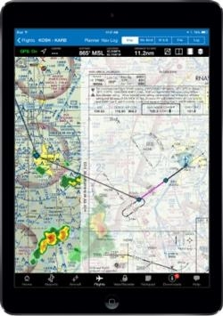
iFlightPlanner has released v2.2 for iPad, the third major update this year to iFlightPlanner for the device presented by Sennheiser.  In addition to numerous performance and usability enhancements, v2.2 now offers the comprehensive set of high-resolution, georeferenced FAA airport diagrams and instrument approach procedures.

The new georeferenced airport diagrams and instrument approach procedures are accessible throughout iFlightPlanner for iPad, including its split-screen view, and can be easily placed over iFlightPlanner’s seamless VFR and IFR charts with a single tap.  Pilots can then use the intuitive mini-menu to quickly search for and switch between other diagrams or approach procedures and adjust the transparency of each.

“We developed our own, proprietary georeferencing process so that when viewed as standalone documents, iFlightPlanner could provide the georeferenced airport diagrams and approach procedures in their original PDF format,” said John Burnside, iFlightPlanner’s Co-Founder & Director of Technology.  “Doing this fully-leverages the pinch and zoom capabilities of the iPad and provides crystal clear readability at any zoom level.”

iFlightPlanner also enhanced its implementation of the Baron Weather API as part of this release, offering pilots the ability to adjust the transparency of RADAR and satellite imagery displayed over its charts and maps.

The new graphical weather functionality is available to all iFlightPlanner Free and Premium members.  Georeferenced airport diagrams and approach procedures are available to iFlightPlanner Premium Plus members, a new membership level introduced to give pilots flying with iFlightPlanner for iPad greater functionality.

(Image provided by iFlightPlanner)

FMI: www.iFlightPlanner.com/Features

Advertisement

More News

ANN's Daily Aero-Term (04.24.24): Runway Lead-in Light System

Runway Lead-in Light System Runway Lead-in Light System Consists of one or more series of flashing lights installed at or near ground level that provides positive visual guidance a>[...]

ANN's Daily Aero-Linx (04.24.24)

Aero Linx: Aviation Without Borders Aviation Without Borders uses its aviation expertise, contacts and partnerships to enable support for children and their families – at hom>[...]

Aero-FAQ: Dave Juwel's Aviation Marketing Stories -- ITBOA BNITBOB

Dave Juwel's Aviation Marketing Stories ITBOA BNITBOB ... what does that mean? It's not gibberish, it's a lengthy acronym for "In The Business Of Aviation ... But Not In The Busine>[...]

Classic Aero-TV: Best Seat in The House -- 'Inside' The AeroShell Aerobatic Team

From 2010 (YouTube Version): Yeah.... This IS A Really Cool Job When ANN's Nathan Cremisino took over the lead of our Aero-TV teams, he knew he was in for some extra work and a lot>[...]

Airborne Affordable Flyers 04.18.24: CarbonCub UL, Fisher, Affordable Flyer Expo

Also: Junkers A50 Heritage, Montaer Grows, Dynon-Advance Flight Systems, Vans' Latest Officially, the Carbon Cub UL and Rotax 916 iS is now in its 'market survey development phase'>[...]

blog comments powered by Disqus


Advertisement

Advertisement

Podcasts

Advertisement

© 2007 - 2024 Web Development & Design by Pauli Systems, LC