NOAA Finalizes 'Graphic Forecasts For Aviation' | Aero-News Network
Aero-News Network
RSS icon RSS feed
podcast icon MP3 podcast
Subscribe Aero-News e-mail Newsletter Subscribe

Airborne Unlimited -- Most Recent Daily Episodes

Episode Date

Airborne-Monday

Airborne-Tuesday

Airborne-Wednesday Airborne-Thursday

Airborne-Friday

Airborne On YouTube

Airborne-Unlimited-05.06.24

Airborne-NextGen-05.07.24

Airborne-Unlimited-05.08.24 Airborne-FlightTraining-05.09.24

Airborne-Unlimited-05.10.24

Tue, Apr 18, 2017

NOAA Finalizes 'Graphic Forecasts For Aviation'

Experimental Weather Product Now Operational

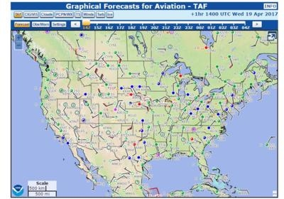
The National Oceanic and Atmospheric Administration (NOAA) has upgraded its experimental "Graphic Forecasts for Aviation" (GFA) to operational status as of Saturday. The new product is accepted by the FAA for weather briefings.

According to NOAA, the Graphical Forecasts for Aviation (GFA) web page is intended to provide the necessary aviation weather information to give users a complete picture of the weather that may impact flight in the continental United States (CONUS). The web page includes observational data, forecasts, and warnings that can be viewed from 14 hours in the past to 15 hours in the future, including thunderstorms, clouds, flight category, precipitation, icing, turbulence and wind. Hourly model data and forecasts, including information on clouds, flight category, precipitation, icing, turbulence, wind, and graphical output from the National Weather Service’s National Digital Forecast Data (NDFD), are available.

Wind, icing and turbulence forecasts are available in 3,000 ft. increments from the surface up to 30,000 ft. MSL, and in 6,000 ft. increments from 30,000 MSL to FL480 (48,000 ft. MSL). Turbulence forecasts are also broken into LO (below 18,000 MSL) and HI (at or above 18,000 MSL) graphics.

A maximum icing graphic and maximum wind velocity graphic (regardless of altitude) are also available. Built with modern geospatial information tools, users can pan and zoom to focus on areas of greatest interest.

The majority of the weather elements contained in the FA are already available through existing NWS products, NOAA says. To maintain continuity of service, the GFA will ensure the availability of equivalent information in addition to adding graphical displays of the predominant weather, sky cover, and wind speed and direction.

(Source: NOAA)

FMI: http://aviationweather.ncep.noaa.gov/gfa
 

Advertisement

More News

Aero-News: Quote of the Day (05.09.24)

"Fly-by-wire flight, coupled with additional capability that are being integrated into ALFA, provide a great foundation for Bell to expand on its autonomous capabilities. This airc>[...]

ANN's Daily Aero-Term (05.09.24): Hold Procedure

Hold Procedure A predetermined maneuver which keeps aircraft within a specified airspace while awaiting further clearance from air traffic control. Also used during ground operatio>[...]

ANN's Daily Aero-Linx (05.09.24)

Aero Linx: B-21 Raider The B-21 Raider will be a dual-capable penetrating strike stealth bomber capable of delivering both conventional and nuclear munitions. The B-21 will form th>[...]

Airborne 05.03.24: Advanced Powerplant Solutions, PRA Runway Woes, Drone Racing

Also: Virgin Galactic, B-29 Doc to Allentown, Erickson Fire-Fighters Bought, FAA Reauthorization After dealing with a big letdown after the unexpected decision by Skyreach to disco>[...]

Airborne-NextGen 05.07.24: AI-Piloted F-16, AgEagle, 1st 2 WorldView Sats

Also: Skydio Chief, Uncle Sam Sues, Dash 7 magniX, OR UAS Accelerator US Secretary of the Air Force Frank Kendall was given a turn around the patch in the 'X-62A Variable In-flight>[...]

blog comments powered by Disqus


Advertisement

Advertisement

Podcasts

Advertisement

© 2007 - 2024 Web Development & Design by Pauli Systems, LC