FAA, AMA: Do Not Fly Near Hurricane Response Efforts | Aero-News Network
Aero-News Network
RSS icon RSS feed
podcast icon MP3 podcast
Subscribe Aero-News e-mail Newsletter Subscribe

Airborne Unlimited -- Most Recent Daily Episodes

Episode Date

Airborne-Monday

Airborne-Tuesday

Airborne-Wednesday Airborne-Thursday

Airborne-Friday

Airborne On YouTube

Airborne-Unlimited-04.22.24

Airborne-Unlimited-04.16.24

Airborne-FlightTraining-04.17.24 Airborne-AffordableFlyers-04.18.24

Airborne-Unlimited-04.19.24

Join Us At 0900ET, Friday, 4/10, for the LIVE Morning Brief.
Watch It LIVE at
www.airborne-live.net

Fri, Oct 07, 2016

FAA, AMA: Do Not Fly Near Hurricane Response Efforts

Clear Skies Needed For Recovery Efforts In Coastal States

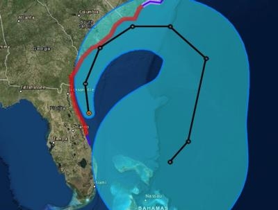
Hurricane Matthew is continuing to grind up the Florida coast, heading for Georgia, South and North Carolina. We know it will be very tempting to get aerial video of the damage caused by hurricane Matthew after the storm has passed. But the FAA and AMA are urging all drone and model aircraft hobbyists to stay clear of Hurricane Matthew recovery efforts in areas affected by the storm.

Any unauthorized drone or model aircraft operations that interfere with disaster relief efforts are subject to civil penalties of up to $32,140 per violation and possible criminal prosecution.
 
During emergency response and recovery efforts, authorized aircraft may be flying at low altitudes over the affected areas. The FAA may also place Temporary Flight Restrictions (TFRs) on certain locations around the storm. UAS operators should always check the FAA’s list of TFRs before taking to the skies and must stay clear of ongoing public safety operations at all times.
 
AMA continually shares up-to-date safety and regulatory information with its 195,000 members across the country, including email distribution of the latest TFRs. For more information on where to fly safely, including TFRs and local AMA club locations, visit the Learn sUAS Interactive Map. In addition, anyone with a smartphone can access TFR information through the FAA’s B4UFLY app.
 
"No one should be flying near disaster relief or recovery efforts, air ambulance or search-and-rescue operations unless they’re supporting those efforts,” said Dave Mathewson, executive director of AMA. “Keeping the skies clear during this critical time will help ensure that first responders can do their jobs safely.”

(Source: AMA news release. National Hurricane Center image)

FMI: https://pilotweb.nas.faa.gov, www.modelaircraft.org

Advertisement

More News

ANN's Daily Aero-Term (04.25.24): Airport Rotating Beacon

Airport Rotating Beacon A visual NAVAID operated at many airports. At civil airports, alternating white and green flashes indicate the location of the airport. At military airports>[...]

ANN's Daily Aero-Linx (04.25.24)

Aero Linx: Fly for the Culture Fly For the Culture, Inc. is a 501(c)(3) non-profit organization that serves young people interested in pursuing professions in the aviation industry>[...]

Klyde Morris (04.22.24)

Klyde Is Having Some Issues Comprehending The Fed's Priorities FMI: www.klydemorris.com>[...]

Airborne 04.24.24: INTEGRAL E, Elixir USA, M700 RVSM

Also: Viasat-uAvionix, UL94 Fuel Investigation, AF Materiel Command, NTSB Safety Alert Norges Luftsportforbund chose Aura Aero's little 2-seater in electric trim for their next gli>[...]

Airborne 04.22.24: Rotor X Worsens, Airport Fees 4 FNB?, USMC Drone Pilot

Also: EP Systems' Battery, Boeing SAF, Repeat TBM 960 Order, Japan Coast Guard H225 Buy Despite nearly 100 complaints totaling millions of dollars of potential fraud, combined with>[...]

blog comments powered by Disqus


Advertisement

Advertisement

Podcasts

Advertisement

© 2007 - 2024 Web Development & Design by Pauli Systems, LC