NASA C-20A Completes Radar Study Of Pacific Rim Volcanoes | Aero-News Network
Aero-News Network
RSS icon RSS feed
podcast icon MP3 podcast
Subscribe Aero-News e-mail Newsletter Subscribe

Airborne Unlimited -- Most Recent Daily Episodes

Episode Date

Airborne-Monday

Airborne-Tuesday

Airborne-Wednesday Airborne-Thursday

Airborne-Friday

Airborne On YouTube

Airborne-Unlimited-04.29.24

Airborne-NextGen-04.30.24

Airborne-Unlimited-05.01.24 Airborne-AffordableFlyers--05.02.24

Airborne-Unlimited-05.03.24

Tue, Oct 23, 2012

NASA C-20A Completes Radar Study Of Pacific Rim Volcanoes

Modified Gulfstream III Made 10 Flights Conducting The Research Over Eight Days

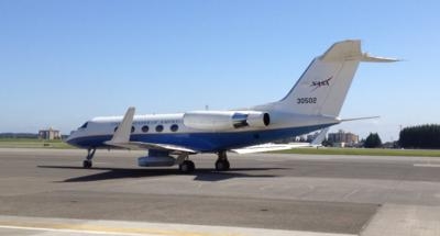
NASA's Airborne Science C-20A aircraft (pictured), carrying a specialized synthetic aperture radar, recently completed a mission to study active volcanoes in Alaska, Aleutian Islands and Japan in early October. The aircraft, a modified version of the Gulfstream III business jet, made 10 flights totaling more than 50 hours during the eight-day campaign. The Uninhabited Aerial Vehicle Synthetic Aperture Radar (UAVSAR), developed and operated by NASA's Jet Propulsion Laboratory, collected 60 of 61 planned data lines.

UAVSAR provides a measurement system that complements satellite-based observations by providing rapid revisits and imaging of active volcanoes to better understand their deformation prior to, during or after an eruption. The flight path took the aircraft north from California, imaging the volcanoes of the Western United States, en route to an overnight stay at Joint Base Elmendorf-Richardson near Anchorage, AK.

After departing Elmendorf, the NASA aircraft imaged volcanoes in Alaska and the Aleutian Islands before arriving at Yokota Air Base near Tokyo, Japan. Yokota was the staging location for science missions that collected data about volcanoes on several islands in Japan that pose a hazard to nearby populations.

Working closely with the Japan Aerospace Exploration Agency (JAXA), three volcano-imaging flights were flown from Yokota over various volcano and disaster monitoring sites throughout Japan between Oct. 5 and 8. The aircraft repeated the outbound routing during the return flights to its home base at the Dryden Aircraft Operations Facility in Palmdale, CA.

John McGrath, C-20A project manager at NASA Dryden, said a mission of this complexity faced numerous challenges. "Preparation has been ongoing since May," McGrath commented. "We had tremendous support from both Elmendorf and Yokota air bases and our colleagues at JAXA."

FMI: www.nasa.gov

Advertisement

More News

ANN's Daily Aero-Linx (05.02.24)

Aero Linx: Model Aeronautical Association of Australia MAAA clubs are about fun flying, camaraderie and community. For over 75 years, the MAAA has been Australia’s largest fl>[...]

ANN's Daily Aero-Term (05.02.24): Touchdown Zone Lighting

Touchdown Zone Lighting Two rows of transverse light bars located symmetrically about the runway centerline normally at 100 foot intervals. The basic system extends 3,000 feet alon>[...]

Aero-News: Quote of the Day (05.02.24)

“Discovery and innovation are central to our mission at Virgin Galactic. We’re excited to build on our successful record of facilitating scientific experiments in subor>[...]

ANN FAQ: Contributing To Aero-TV

How To Get A Story On Aero-TV News/Feature Programming How do I submit a story idea or lead to Aero-TV? If you would like to submit a story idea or lead, please contact Jim Campbel>[...]

NTSB Final Report: Cirrus Design Corp SR20

Student Pilot Reported That During Rotation, “All Of A Sudden The Back Of The Plane Kicked To The Right..." Analysis: The student pilot reported that during rotation, “>[...]

blog comments powered by Disqus


Advertisement

Advertisement

Podcasts

Advertisement

© 2007 - 2024 Web Development & Design by Pauli Systems, LC