Wed, Apr 21, 2010
NLR Research Aircraft Used To Verify Movement Of The Cloud
 The National Aerospace Laboratory's (NLR) research aircraft
has investigated the volcanic ash cloud hovering over the
Netherlands. The purpose of this flight was to verify the accuracy
of atmospheric models currently being used to predict the movements
of the ash cloud.
The National Aerospace Laboratory's (NLR) research aircraft
has investigated the volcanic ash cloud hovering over the
Netherlands. The purpose of this flight was to verify the accuracy
of atmospheric models currently being used to predict the movements
of the ash cloud.
From the flight undertaken by the Cessna Citation on Sunday
night above the Netherlands' southern provinces, it emerged that
the ash cloud is highly visible. The edges of the ash cloud
hovering above the country's southern provinces were also highly
visible, which is crucial information for pilots when the air space
is (temporarily) opened.
The objective of this flight was to verify the accuracy of the
models the Royal Netherlands Meteorological Institute uses to
calculate the movements of the volcanic ash cloud. These
measurements are then used by the Dutch aviation authorities to
take decisions regarding the closing and (re)opening of air
space.
Sunday night's flight revealed that the models had accurately
estimated the location of the volcanic ash layer. The NLR's
research aircraft flew over the ash cloud, which at the time was
hovering at a height of 1.8 miles and was comprised of varying
thicknesses.
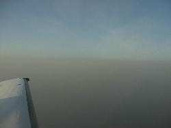
NLR Photo
There are very few methods currently available in Europe for
precisely measuring and tracking volcanic ash. Moreover, there are
no set regulations in place for determining which ash particle
concentration levels necessitate the opening (or closing) of air
space. NLR researchers are therefore currently working closely with
other institutes, including the Royal Netherlands Meteorological
Institute, the National Institute for Public Health and the
Environment, the Dutch Ministry of Defence, the Ministry of
Transport, Public Works and Water Management, and Eurocontrol. This
joint research will determine the best methods for quickly and
safely launching sensors and measuring instruments capable of
accurately monitoring volcanic ash.
More News
Aero Linx: JAARS Nearly 1.5 billion people, using more than 5,500 languages, do not have a full Bible in their first language. Many of these people live in the most remote parts of>[...]
'Airplane Bounced Twice On The Grass Runway, Resulting In The Nose Wheel Separating From The Airplane...' Analysis: The pilot reported, “upon touchdown, the plane jumped back>[...]
"Burt is best known to the public for his historic designs of SpaceShipOne, Voyager, and GlobalFlyer, but for EAA members and aviation aficionados, his unique concepts began more t>[...]
"Polaris Dawn, the first of the program’s three human spaceflight missions, is targeted to launch to orbit no earlier than summer 2024. During the five-day mission, the crew >[...]
There Are SO Many Ways To Get YOUR Aero-News! It’s been a while since we have reminded everyone about all the ways we offer your daily dose of aviation news on-the-go...so he>[...]
 ANN's Daily Aero-Linx (05.04.24)

