Aero-TV: Pro Line Fusion -- 'Touch What You Want to Change' | Aero-News Network
Aero-News Network
RSS icon RSS feed
podcast icon MP3 podcast
Subscribe Aero-News e-mail Newsletter Subscribe

Airborne Unlimited -- Most Recent Daily Episodes

Episode Date

Airborne-Monday

Airborne-Tuesday

Airborne-Wednesday Airborne-Thursday

Airborne-Friday

Airborne On YouTube

Airborne-Unlimited-04.22.24

Airborne-Unlimited-04.16.24

Airborne-FlightTraining-04.17.24 Airborne-AffordableFlyers-04.18.24

Airborne-Unlimited-04.19.24

Join Us At 0900ET, Friday, 4/10, for the LIVE Morning Brief.
Watch It LIVE at
www.airborne-live.net

Fri, Oct 14, 2011

Aero-TV: Pro Line Fusion -- 'Touch What You Want to Change'

Touch-Screen Functionality Comes To Pro Line Avionics

When flying complex airplanes in instrument or other challenging conditions, anything that makes it easier for the flight crew to concentrate on flying the airplane is a good thing. Rockwell Collins was out of the gate early at Oshkosh this summer, introducing its touch-screen interface for the Pro Line Fusion Primary Flight Display.

"The theory is 'touch what you want to change'," says Rockwell Collins' Adam Evanschwartz. He says that the system is unique in the marketplace because of its HUD capability which allows pilots to increase their situational awareness while interacting with the PFD and MFD.

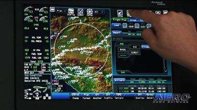
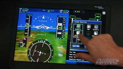
Evan Schwartz says that pilots find the system very intuitive after about a half hour of flying. In his demonstration, a touch in the center of the PFD brings up a menu which allows the system to be divided into two parts, showing primary instruments and synthetic vision on one side of the PFD, and a GPS terrain map on the other.

An icon-driven drag-and-drop interface allows pilots to change the display to show charts for primary, alternate, or enroute, and that display can also be divided into two equal parts for the display of even more granular data such as checklists.

The moving map function also allows the pilot to update route of flight by "rubber banding" the course line displayed for easy vectoring around weather, or a change in waypoints or primary and alternate airports. Weather radar and other information can also be overlayed on the moving maps.

FMI: www.rockwellcollins.com, www.youtube.com/aerotvnetwork, http://twitter.com/AeroNews


Advertisement

More News

ANN's Daily Aero-Term (04.26.24): DETRESFA (Distress Phrase)

DETRESFA (Distress Phrase) The code word used to designate an emergency phase wherein there is reasonable certainty that an aircraft and its occupants are threatened by grave and i>[...]

ANN's Daily Aero-Linx (04.26.24)

Aero Linx: The International Association of Missionary Aviation (IAMA) The International Association of Missionary Aviation (IAMA) is comprised of Mission organizations, flight sch>[...]

Airborne 04.22.24: Rotor X Worsens, Airport Fees 4 FNB?, USMC Drone Pilot

Also: EP Systems' Battery, Boeing SAF, Repeat TBM 960 Order, Japan Coast Guard H225 Buy Despite nearly 100 complaints totaling millions of dollars of potential fraud, combined with>[...]

Airborne 04.24.24: INTEGRAL E, Elixir USA, M700 RVSM

Also: Viasat-uAvionix, UL94 Fuel Investigation, AF Materiel Command, NTSB Safety Alert Norges Luftsportforbund chose Aura Aero's little 2-seater in electric trim for their next gli>[...]

Airborne-NextGen 04.23.24: UAVOS UVH 170, magni650 Engine, World eVTOL Directory

Also: Moya Delivery Drone, USMC Drone Pilot, Inversion RAY Reentry Vehicle, RapidFlight UAVOS has recently achieved a significant milestone in public safety and emergency services >[...]

blog comments powered by Disqus


Advertisement

Advertisement

Podcasts

Advertisement

© 2007 - 2024 Web Development & Design by Pauli Systems, LC