Tue, Nov 24, 2009
WSI Pilotbrief Online takes the award-winning WSI Pilotbrief
weather service suite and provides pilots immediate access to
up-to-date enhanced weather updates anywhere, anytime from any
Internet-enabled web browser. One of the few online weather
services with FAA Qualified Internet Communications Provider (QICP)
certification, Pilotbrief Online allows clients to file flight
plans directly to the FAA, as well as view their preferred routes
and briefing preferences at any of the numerous WSI Pilotbrief
kiosks located in FBO’s throughout the country.

Through Pilotbrief Online’s secure connection, pilots have
direct access to all of WSI’s aviation data including WSI
NOWrad radar imagery, IR and Visible Satellite imagery, graphical
METARs, TFRs, AIRMETS and SIGMETS. Radar summary charts
indicate potential weather hazards, such as tornadic vortex
signatures and mesocyclones, within a planned route for a proactive
approach to changing operational conditions. In addition, the
en-route SIGMETS and Flight Plan Guidance provide forecasts for
turbulence, convection, and icing, as well as up-to-the-minute Auto
Plotted SIGMET and AIRMET charts showing boundaries of in-flight
advisories.

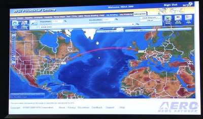
With WSI’s Interactive Map, pilots can quickly and easily
view global flight data, including route-centric visualization, on
a single, easy-to-use interactive workspace. The enhanced map is
able to display pole-to-pole, high-resolution digital elevation
models with 16 individual weather, hazard, and route
overlays. Such layers include boxes showing areas of
turbulence, icing conditions, and even a lightning layer that uses
the Global Lightning Network to display real-time lightning
detection data for locations throughout the world.
Pilots can graphically combine various aviation weather and
airspace notification layers with just a few mouse clicks.
Developed to be highly extensible, the state-of-the-art interactive
map technology allows any future upgrades to be easily added for
enhanced options.
More News
From 2023 (YouTube Version): Legacy of a Titan Robert (Bob) Anderson Hoover was a fighter pilot, test pilot, flight instructor, and air show superstar. More so, Bob Hoover was an i>[...]
Get The Latest in Aviation News NOW on Instagram Are you on Instagram yet? It's been around for a few years, quietly picking up traction mostly thanks to everybody's new obsession >[...]
Aero Linx: B-52H Stratofortress The B-52H Stratofortress is a long-range, heavy bomber that can perform a variety of missions. The bomber is capable of flying at high subsonic spee>[...]
Altimeter Setting The barometric pressure reading used to adjust a pressure altimeter for variations in existing atmospheric pressure or to the standard altimeter setting (29.92).>[...]
"Knowing that we play an active part in bettering people's lives is extremely rewarding. My team and I are very thankful for the opportunity to be here and to help in any way we ca>[...]
 Classic Aero-TV: Remembering Bob Hoover

