Upgrades Compensate for FAA/AWA Data Migration
In response to the recent FAA/AWS data migration, the boffins at METARmaps have developed a series of forward-looking upgrade plans.
Subject plans—which take into account the fact the legacy processors indigenous to METARmaps are hard-coded to seek data in digital domains no longer extant—consist of:
RPI: Legacy Raspberry PIs will be replaced with the latest D1v2 processor, which accesses METARmaps’s cloud service. The replacement device will be plug-compatible with existing maps.
D1v1: Early D1s will be re-flashed to D1v2 and use METARmaps’s cloud service. Extant D1 processors will need to be returned to METARmaps along with a copy of the Upgrade Order Confirmation. Although NOT a warranty issue, affected maps ordered after 15 October 2021 will be re-flashed at no charge, and a full refund provided when the unit is processed.
D1v2: Unaffected maps utilize D1v2 processor. As all current V4 features are enabled on said units, no subscription cost is incurred.
Once upgraded, existing METARmaps will support the full suite of V4 OS features. Once the company’s systems are modified, customers’ maps will revert to their OEM feature sets. Customers wishing to go on using V4 will be able to do so for a nominal $1.50 monthly fee.
Parties interested in learning more about or ordering the described upgrades are invited to visit https://metarmaps.com/upgrades . Customers ordering upgrades are asked to please have their respective map’s serial numbers at the ready.
Developed by pilot, aircraft-owner, and entrepreneur Richard Freilich, METARmaps are syntheses of visual art and real-time meteorological observations manifested in unique and useful wall decorations.
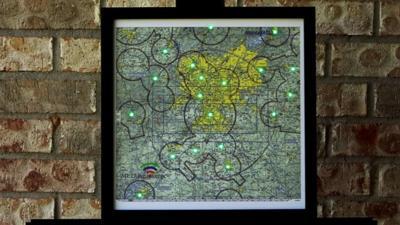
METARmaps consist of meticulous recreations of VFR Sectional Charts—or sections, composites, or collections thereof—imbued with tiny processors controlling the illumination and color of LED lights representing METAR-reporting airports within the chart’s geographical boundaries. The LEDs depict generalized, real-time weather conditions prevailing at the airports represented thereby.
Consistent with the FAA’s chromatic weather depiction scheme, METARmaps LEDs shone green indicate VFR weather conditions. Marginal VFR conditions are represented by blue LEDs. Conversely, IFR and Low-IFR weather conditions are denoted by red and purple LEDs respectively. Flashing LEDs, regardless of color, indicate high winds.
Buyers may add their home airports (singular) free of charge. Additional custom airports may be added to METARmaps for $25-apiece.
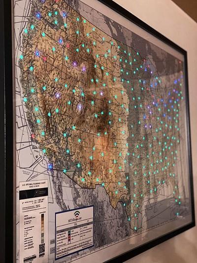
Among the more popular METARmaps is a 36" (wide) x 24" (high) x 1" (deep) depiction of the contiguous United States. The matte-black-framed, poly-glazed, Medium Density Fiberboard (MDF) objed d’art features nearly 250 LEDs, each representing a METAR reporting airport.
By dint of a mobile-telephone (no app required), METARmaps owners can customize display parameters the likes of update-rate, wind, wind-gust, and lightning depictions.
To function, METARmaps require 2.4 GHZ Wi-Fi Internet access, AC power, and a suitable surface upon which to hang. It should be noted that only METAR-reporting airports with runways four-thousand-feet or longer are represented on METARmaps.
To the subject of his creations, Mr. Freilich stated: “METARmaps have been embraced across all sectors: general aviation pilots, commercial aviation, Fixed Base Operators (FBO’s), Avidyne, ForeFlight, including Air Traffic Controllers, meteorologists, and others.”
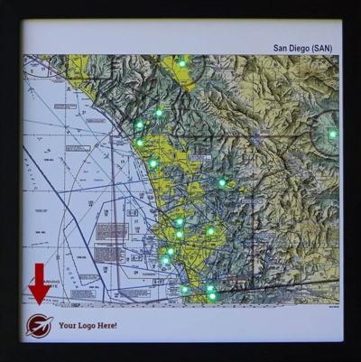
Smaller METARmaps depicting Terminal Area Charts have also proved popular. Currently, no fewer than forty terminal areas—from Atlanta and Austin to Memphis and Miami to Toronto and Vancouver—are available.
Pricing for METARmaps ranges from approximately $200 for terminal areas to $475-$685 for individual U.S. states and geographical regions to as much as $1,899 for a sprawling triptych of the contiguous United States. The latter features nearly six-hundred airports distributed across three panels, each measuring 36” (high) x 20” (wide).
All METARmaps are built to order in the United States. Every unit undergoes an extensive testing process and compulsory burn-in process. Ergo, buyers should expect to take possession of their METARmaps four-to-six weeks after ordering such.
 ANN's Daily Aero-Term (05.05.24): Omnidirectional Approach Lighting System

