Terra Drone Evaluating GPR Services | Aero-News Network
Aero-News Network
RSS icon RSS feed
podcast icon MP3 podcast
Subscribe Aero-News e-mail Newsletter Subscribe

Airborne Unlimited -- Most Recent Daily Episodes

Episode Date

Airborne-Monday

Airborne-Tuesday

Airborne-Wednesday Airborne-Thursday

Airborne-Friday

Airborne On YouTube

Airborne-Unlimited-05.06.24

Airborne-NextGen-04.30.24

Airborne-Unlimited-05.01.24 Airborne-AffordableFlyers--05.02.24

Airborne-Unlimited-05.03.24

Tue, Aug 06, 2019

Terra Drone Evaluating GPR Services

Drone-Deployed Ground Penetrating Radar Would Support Construction And Mining Activities

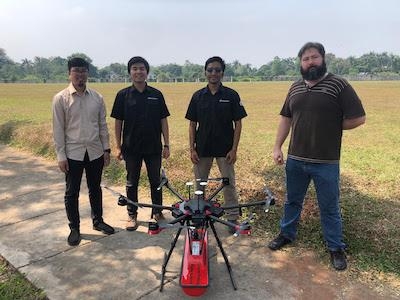
Terra Drone is in the process of evaluating the use of Ground Penetrating Radar (GPR) carried by drones to support the construction and mining industries.

At present, several trials are being carried out in several cases such as making maps of underground pipelines, modeling soil structures in the valley area and detecting the condition of pipes across the river. In this case, Terra Drone took one of his partners from Europe to carry out the trial.
 
Similar to LiDAR, which was previously introduced by Terra Drone, GPR is not a new technology concept, and has been widely used for soil modeling purposes. In principle, GPR shoots electromagnetic waves into the ground, which are then reflected due to differences in the character and density of soil structures, which are then translated by geophysicists to understand in detail the results of the survey. The data collection process is quite simple. However, there are many obstacles that sometimes hinder the process of retrieving data so that the process becomes difficult. One problem is the uneven and dangerous field conditions, difficult access to the mapping location, longer work time, weather conditions and more. With the use of drones, it is expected that these obstacles can be answered, so that the productivity of GPR scanning can increase and the economic value increases rapidly.

The use of drone technology that can bring various sensors for mapping activities is increasingly becoming a solution in various jobs, especially those that are high in risk and danger. Drones with short flight times can reach large mapping areas so that they are efficient in time but still provide accurate results.

This GPR Drone Solution is expected to be a useful innovation in various sectors. Terra Drone will start providing these solutions in Indonesia by the end of 2019.

(Image provided with Terra Drone news release)

FMI: www.terra-drone.co.id

Advertisement

More News

ANN's Daily Aero-Term (05.05.24): Omnidirectional Approach Lighting System

Omnidirectional Approach Lighting System ODALS consists of seven omnidirectional flashing lights located in the approach area of a nonprecision runway. Five lights are located on t>[...]

Aero-News: Quote of the Day (05.05.24)

"Polaris Dawn, the first of the program’s three human spaceflight missions, is targeted to launch to orbit no earlier than summer 2024. During the five-day mission, the crew >[...]

Airborne 05.06.24: Gone West-Dick Rutan, ICON BK Update, SpaceX EVA Suit

Also: 1800th E-Jet, Uncle Sam Sues For Landing Gear, Embraer Ag Plane, Textron Parts A friend of the family reported that Lt. Col. (Ret.) Richard Glenn Rutan flew west on Friday, M>[...]

Airborne 05.03.24: Advanced Powerplant Solutions, PRA Runway Woes, Drone Racing

Also: Virgin Galactic, B-29 Doc to Allentown, Erickson Fire-Fighters Bought, FAA Reauthorization After dealing with a big letdown after the unexpected decision by Skyreach to disco>[...]

Aero-News: Quote of the Day (05.06xx.24)

“Our aircrews are trained and capable of rapidly shifting from operational missions to humanitarian roles. We planned to demonstrate how we, and our BORSTAR partners, respond>[...]

blog comments powered by Disqus


Advertisement

Advertisement

Podcasts

Advertisement

© 2007 - 2024 Web Development & Design by Pauli Systems, LC