All Passengers And Crew Were Safely Evacuated From The Airplane
The NTSB has released an investigative update from the runway excursion which occurred at Naval Air Station (NAS) Jacksonville (FL) (KNIP) May 3. The Boeing 737-800 operating as a charter flight from Guantanamo Bay, Cuba exited the runway and came to a stop in shallow water in the St. Johns River adjacent to the base.
According to the report, on the night of the accident, the KNIP automated surface observation system (ASOS) special weather observation at 2122 (20 minutes before the accident) indicated wind from 350° at 4 knots, 5 miles visibility, heavy rain and thunderstorms, mist, scattered clouds at 800 ft above ground level (agl), broken ceiling of cumulonimbus clouds at 1,800 ft agl, overcast skies at 3,000 ft agl, temperature 24°C, and dew point 22°C. The remarks noted that thunderstorms began at 2104, frequent lightning was overhead, the thunderstorms overhead were moving east, and 0.10 inch of precipitation fell since 2053.
The KNIP ASOS special weather observation at 2145 (3 minutes after the accident) indicated wind from 290° at 8 knots with gusts to 16 knots, 3 miles visibility, heavy rain and thunderstorms, mist, scattered clouds at 800 ft agl, broken ceiling of cumulonimbus clouds at 1,500 ft agl, overcast skies at 3,200 ft agl, temperature 24°C, and dew point 22°C. The remarks included that 0.63 inch of precipitation had fallen since 2053. Figure 1 shows the Jacksonville (KJAX) WSR-88D base reflectivity image for the 0.5° elevation scan initiated at 2143:17.
ATC communications indicated that, at 2122:19, the pilot checked in with a Jacksonville approach (JAX) controller while level at 13,000 ft mean sea level (msl) and was provided the JAX altimeter setting; the controller advised the pilot to expect the RNAV RWY28 approach and moderate-to-heavy precipitation on the final approach to RWY28. The JAX controller then called the KNIP tower controller and asked for the current winds and precipitation out the window. The KNIP controller said the winds were from 350° at 4 knots, 5 miles visibility, heavy thunderstorms, rain, and mist.
At 2123:25, the JAX controller advised the pilot that the winds at KNIP were from 350° at 4 knots; the pilot then asked if there was any chance of getting RWY10 because it looked a little better. The JAX controller responded that he was showing moderate-to-heavy precipitation building over RWY10 starting about 5 miles on final. The pilot acknowledged and said he would stick with RWY28. He was then instructed to descend and maintain 5,000 ft.
At 2124:55, the JAX controller called the KNIP tower again and asked if RWY10 or RWY28 looked better out the window. The KNIP tower controller advised that both runways were “pretty rough,” the runways were “pretty socked in,” and the winds favored RWY28. The JAX controller advised the pilot that the KNIP tower controller reported that both runways looked “pretty bad” and were “socked in.” Additionally, he advised the pilot of moderate-to-heavy precipitation east and west of KNIP and asked if the pilot would like the RNAV RWY28 approach. The pilot responded that he would like that approach and would check how it was when he got closer. At 2126:11, the JAX controller instructed the flight to turn right to a heading of 010° and to descend and maintain 3,000 feet. At 2127:56, the JAX controller instructed the flight to turn right to a heading of 040°. The pilot acknowledged the instructions. At 2130:03, the JAX controller advised the pilot that the
flight was heading northbound and the precipitation was moving eastbound; the controller then asked the pilot if he would like to try RWY10 since it might be better. The pilot acknowledged "yeah go ahead, let’s do it." The controller then instructed the pilot to turn left to a heading of 270°, and the pilot acknowledged. Over the next several minutes, the flight was vectored for the approach to runway 10. At 2137:35, the JAX controller cleared the flight for the RNAV RWY 10 approach, and the pilot acknowledged. Shortly after, the flight was transferred to the KNIP radar controller.

The pilot contacted the KNIP radar controller, and, at 2139:49, the KNIP radar controller indicated the winds were from 240° at 10 knots; he then cleared the flight to land on runway 10. The pilot acknowledged the landing clearance when the airplane was about 5 nautical miles from the runway threshold. At 2141:10, the KNIP radar controller instructed the pilot to report the field in sight, to which the pilot immediately responded he had the field in sight. There was no further communications between the pilot and controller. At 2142:22, the emergency locator transmitter (ELT) was heard on the frequency.
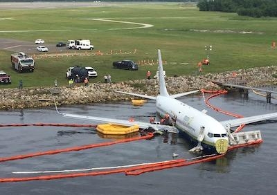
The airplane impacted a rock embankment at the end of the runway 10 overrun area before coming to rest in the St. Johns River about 1,200 ft from the end of runway 10 (NTSB image above). The center of the airplane was about 100 ft east of the river’s shoreline and about 75 ft south of the runway 28 landing light pier. The water where the airplane came to rest was 3-5 ft deep, depending on the tidal conditions. The embankment had a distinct area of disturbed rocks, consistent with the engines and main landing gear impacting the embankment. The airplane was mostly intact, but both main landing gear had separated from the airplane and were also located in the river.
Company and FAA records indicated that the captain was qualified and current in the airplane and held an FAA airline transport pilot certificate with type ratings for the Boeing B727, Boeing B737, Fairchild-Swearingen SA-227, and the Saab SF-340. He had a current FAA first-class medical certificate with no limitations or restrictions. He had worked for Miami Air since March 2008 and had about 7,500 hours of total flight experience, with about 2,000 hours as second-in-command and 1,000 hours as pilot-in-command in the B737.
The first officer held an FAA airline transport pilot certificate with a Boeing B737 type rating. He had a current FAA first-class medical certificate with no limitations or restrictions. He was hired by Miami Air in January 2019 and had about 7,500 hours of total flight experience with about 18 hours in the B737.
(NTSB images)
 ANN's Daily Aero-Term (11.29.25): Waypoint

