Offers 'Powerful' Full-Frame Camera Payload For Aerial Surveying
DJI has unveiled two new payload solutions for its Matrice 300 RTK commercial drone platform.
"With these two new payloads, we are providing an all-integrated complete solution to our enterprise customers active in accurate geospatial data acquisition," said Arjun Menon, Engineering Manager at DJI in the US. "Having a fully integrated capable and affordable Lidar seamlessly integrated into our best commercial drone is a dream that becomes reality for surveying, mapping and construction professionals. They will be able to see, cover and understand the geospatial context from a totally new perspective thanks to the high level of accuracy and quality of the data collected from these tools in the sky."
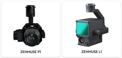
In the aerial surveying industry, Lidar technology plays a vital role in building accurate reality models. In low light situations, or in areas with heavy foliage where traditional drone-based photogrammetry methods would fall short, Lidar can provide quick, precise true-color point cloud models of complex structures. The Zenmuse L1 is DJI's first Lidar solution for aerial surveying.
The Zenmuse L1 integrates a powerful yet ultra-lightweight Livox Lidar module with a 70° FOV, a high-accuracy IMU, and a 20-megapixel camera with a 1-inch CMOS sensor and a mechanical shutter on a 3-axis stabilized gimbal. The Zenmuse L1 can generate true-color point cloud models in real-time, or acquire a vast area (up to 2 km2) of point cloud data in a single flight. With a Point Rate of 240.000 points per second and a detection range of 450 meters, the ease and speed of capturing quality Lidar data is unprecedented. The module supports both Line Scan Mode and Non-repetitive Scanning Mode, a unique technology developed by Livox. This will provide full coverage of the area of interest in very short amounts of time, and allows the sensor to capture data in any direction, instead of along a defined plane.

When used with DJI's Matrice 300 RTK and DJI Terra surveying software, it becomes a complete and versatile solution that gives the user real-time 3D data throughout the day, efficiently capturing the details of complex structures and delivering highly accurate reconstructed models. Thanks to its IP44 rating, The Zenmuse L1 can operate in rainy or foggy environments while the Lidar module's active scanning method enables flights in low light conditions.
The new DJI Zenmuse P1 is the most powerful DJI camera payload dedicated to geospatial data acquisition. It integrates a 45-megapixel full-frame low-noise high-sensitivity sensor offering flexible viewing with interchangeable 24/35/50mm fixed-focus lenses on a 3-axis stabilized gimbal. The DJI Zenmuse P1 provides high accuracy without Ground Control Points (3cm horizontally / 5cm vertically) and high efficiency as it is able to cover 3 km2 in a single flight.
Equipped with a mechanical shutter and the all-new TimeSync 2.0 system, which synchronizes time across modules at the microsecond level, the Zenmuse P1 lets users capture centimeter-accurate data combined with real-time position and orientation compensation technology.
The Smart Oblique Capture feature dramatically improves efficiency, mimicking a multi-sensor oblique camera, and only capturing the photos essential to the reconstruction at the edge of the mapping areas.
The DJI Zenmuse L1 and DJI Zenmuse P1 will start shipping in early 2021.
 Aero-FAQ: Dave Juwel's Aviation Marketing Stories -- ITBOA BNITBOB

