Avidyne has announced that XM WX
Satellite Weather service will be available to operators of
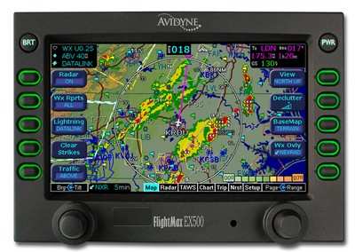
FlightMax EX500 Multifunction Display (MFD) systems. In addition,
Avidyne announced an attractive limited-time upgrade program for
EX500 owners to add XM WX. This XM Upgrade Program enables EX500
owners to receive the benefits of broadcast datalink capability at
a savings of $1,575.
The XM Upgrade Program will provide a $1,000 rebate from Heads
Up Technologies with the purchase of an XMD-076 transceiver and
antenna (retail price $3750); an EX500 MFD software upgrade ($500
value); and a waiver of the XM subscription registration fee ($75
value), for a total savings of $1,575.
The XM Upgrade Program is available for all EX500 customers who
are registered Narrowcast datalink customers on or before September
30, 2004. Installations need to be completed by December 31,
2004.
FlightMax customers now have an unprecedented amount of
operational flexibility, with three industry-leading options
including:
MultiLink– Avidyne’s exclusive MultiLink technology
seamlessly integrates XM and Narrowcast datalink capability for the
most advanced and easiest-to-use datalink system available,
enabling the FlightMax EX500 to display aviation weather at the
high-speed update rates of XM, while also offering the efficiency
of lower-cost, two-way Narrowcast datalink.
XM– Avidyne’s XM WX Satellite Weather service gives
pilots comprehensive, graphical information about weather
conditions across the U.S., including full-color, high-resolution
NEXRAD Radar overlaid on the EX500’s moving map; graphical
and plain-English textual METARs, AIRMETs, SIGMETs and TFRs; and
lightning strikes from the National Lightning Detection Network. XM
provides full continental United States (CONUS) coverage with no
gaps or altitude restrictions.
Narrowcast– Avidyne’s integrated Narrowcast two-way
datalink system provides route-specific weather data over CONUS,
Canada and the Caribbean on a pay-as-you-go basis, offering a
combination of exceptional value as well as the capacity to offer
such future capabilities as position reporting and air-to-ground
messaging. Narrowcast is an ideal datalink solution for those who
only fly a few hours per month or a few months per year.
Its Offerings Are Lighter, Cleaner, and Now Pushing Past 1,000nm on SAF Jet Fuel DeltaHawk’s diesel-powered aircraft lineup has seen incredible upgrades over the last few yea>[...]
The Airplane Experienced A Total Loss Of Engine Power On December 3, 2025, about 1600 central standard time, a Mooney Aircraft Corp. M20K, N57229, was substantially damaged when it>[...]
Make Sure You NEVER Miss A New Story From Aero-News Network Do you ever feel like you never see posts from a certain person or page on Facebook or Instagram? Here’s how you c>[...]
Aero Linx: European Society of Aerospace Medicine (ESAM) As a pan-European, independent forum, it works to promote the safety and health of all persons involved in aviation and spa>[...]
“We are excited to see Wisk achieve this milestone, and I’m so proud of the team that made it possible. The team at Wisk has built advanced technologies across flight c>[...]

 Aero-TV: DeltaHawks Diesel Power Steps Into the Spotlight

