Thu, Feb 04, 2010
Scientists Hope To Be Able To Measure Tectonic Plate
Movements
JPL's Uninhabited Aerial Vehicle Synthetic Aperture Radar
(UAVSAR) captured this false-color composite image of the city of
Port-au-Prince, Haiti, and the surrounding region on Jan. 27, 2010.
Port-au-Prince is visible near the center of the image. The large
dark line running east-west near the city is the main airport.
UAVSAR left NASA's Dryden Flight Research Center in Edwards, CA,
January 25, aboard a modified NASA Gulfstream III aircraft on a
three-week campaign that will also take it to Central America.
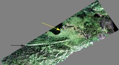
Photo Courtesy JPL
Shortly before 1700 local time on January 12,a magnitude 7.0
earthquake struck southern Haiti. The earthquake's epicenter was
about 25 kilometers (15 miles) west-southwest of Port-au-Prince,
close to the west (left) edge of this image (yellow arrow). The
large linear east-west valley in the mountains south of the city is
the location of the major active fault zone responsible for the
earthquake: the Enriquillo-Plantain Garden fault (black arrow). The
fault extends from the western tip of Haiti past Port-au-Prince
into the Dominican Republic to the east of this image. Historical
records show that the southern part of Haiti was struck by a series
of large earthquakes in the 1700s, and geologists believe those
were also caused by ruptures on this fault zone.
Satellite interferometric synthetic aperture radar measurements
show that the January 12 earthquake ruptured a segment of the fault
extending from the epicenter westward over a length of about 40
kilometers (25 miles), leaving the section of the fault in this
image unruptured. The earthquake has increased the stress on this
eastern section of the fault south of Port-au-Prince and the
section west of the rupture. This has significantly increased the
risk of a future earthquake, according to a recent report by the
U.S. Geological Survey.
This image will be combined with other images of the same area
to be acquired later this month and in the future in order to
measure the motion of Earth's surface during the time between
images using a technique called interferometry.The interferometric
measurements will allow scientists to study the pressures building
up and being released on the fault at depth.
More News
Airport Rotating Beacon A visual NAVAID operated at many airports. At civil airports, alternating white and green flashes indicate the location of the airport. At military airports>[...]
Aero Linx: Fly for the Culture Fly For the Culture, Inc. is a 501(c)(3) non-profit organization that serves young people interested in pursuing professions in the aviation industry>[...]
Klyde Is Having Some Issues Comprehending The Fed's Priorities FMI: www.klydemorris.com>[...]
Also: Viasat-uAvionix, UL94 Fuel Investigation, AF Materiel Command, NTSB Safety Alert Norges Luftsportforbund chose Aura Aero's little 2-seater in electric trim for their next gli>[...]
Also: EP Systems' Battery, Boeing SAF, Repeat TBM 960 Order, Japan Coast Guard H225 Buy Despite nearly 100 complaints totaling millions of dollars of potential fraud, combined with>[...]
 ANN's Daily Aero-Term (04.25.24): Airport Rotating Beacon

