Wounded Eagle UAS Uses Drone To Map VA West Los Angeles Medical Center Campus | Aero-News Network
Aero-News Network
RSS icon RSS feed
podcast icon MP3 podcast
Subscribe Aero-News e-mail Newsletter Subscribe

Airborne Unlimited -- Most Recent Daily Episodes

Episode Date

Airborne-Monday

Airborne-Tuesday

Airborne-Wednesday Airborne-Thursday

Airborne-Friday

Airborne On YouTube

Airborne-Unlimited-04.22.24

Airborne-Unlimited-04.16.24

Airborne-FlightTraining-04.17.24 Airborne-AffordableFlyers-04.18.24

Airborne-Unlimited-04.19.24

Join Us At 0900ET, Friday, 4/10, for the LIVE Morning Brief.
Watch It LIVE at
www.airborne-live.net

Tue, Jun 25, 2019

Wounded Eagle UAS Uses Drone To Map VA West Los Angeles Medical Center Campus

Also Created 3D Renderings Of Several Historical Buildings Including The Wadsworth Chapel And Brentwood Theater

Wounded Eagle (WE) UAS Inc., a veteran run non-profit organization that trains disabled veterans to become experienced and skilled FAA Part 107 UAS operators, has announced that with help from its student UAS operators, it completed aerial mapping of VA Greater Los Angeles Healthcare System's (VAGLAHS) 388-acre VA West Los Angeles Medical Center (WLA) campus.

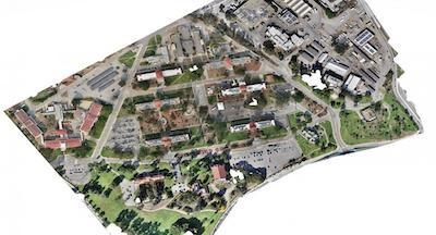
WE used a UAS and UAS mapping software to capture thousands of images of WLA. The images were stitched together to make a three zone orthomosaic map. WE also created 3D renderings of several historical buildings including the Wadsworth Chapel and Brentwood Theater.

“A truly great opportunity was given to Wounded Eagle UAS by the VA,” says Joseph Dorando, the team lead and remote pilot in charge of UAS operations.

“Our student teams are all disabled veterans and to provide them the capability to learn how to make maps using UAS was a real experience for them and gave them the confidence to do more and go beyond.”

Together, WE and the VAGLAHS Emergency Management Office documented existing facilities and created high-resolution imagery of the entire campus for historical purposes.

The image collections were divided into three zones with the option to merge all three collections together to make one large orthomosaic photogrammetric map of the campus. The resolution is .5 cm per pixel, which allows users to zoom in and view fine details of the buildings such as individual rooftop tiles.

(Image provided with Wounded Eagle news release)

FMI: www.weuas.org

Advertisement

More News

ANN's Daily Aero-Term (04.25.24): Airport Rotating Beacon

Airport Rotating Beacon A visual NAVAID operated at many airports. At civil airports, alternating white and green flashes indicate the location of the airport. At military airports>[...]

ANN's Daily Aero-Linx (04.25.24)

Aero Linx: Fly for the Culture Fly For the Culture, Inc. is a 501(c)(3) non-profit organization that serves young people interested in pursuing professions in the aviation industry>[...]

Klyde Morris (04.22.24)

Klyde Is Having Some Issues Comprehending The Fed's Priorities FMI: www.klydemorris.com>[...]

Airborne 04.24.24: INTEGRAL E, Elixir USA, M700 RVSM

Also: Viasat-uAvionix, UL94 Fuel Investigation, AF Materiel Command, NTSB Safety Alert Norges Luftsportforbund chose Aura Aero's little 2-seater in electric trim for their next gli>[...]

Airborne 04.22.24: Rotor X Worsens, Airport Fees 4 FNB?, USMC Drone Pilot

Also: EP Systems' Battery, Boeing SAF, Repeat TBM 960 Order, Japan Coast Guard H225 Buy Despite nearly 100 complaints totaling millions of dollars of potential fraud, combined with>[...]

blog comments powered by Disqus


Advertisement

Advertisement

Podcasts

Advertisement

© 2007 - 2024 Web Development & Design by Pauli Systems, LC