New Mobile Jeppesen EFB Features Introduced | Aero-News Network
Aero-News Network
RSS icon RSS feed
podcast icon MP3 podcast
Subscribe Aero-News e-mail Newsletter Subscribe

Airborne Unlimited -- Most Recent Daily Episodes

Episode Date

Airborne-Monday

Airborne-Tuesday

Airborne-Wednesday Airborne-Thursday

Airborne-Friday

Airborne On YouTube

Airborne-Unlimited-04.29.24

Airborne-Unlimited-04.23.24

Airborne-Unlimited-04.24.24 Airborne-FltTraining-04.25.24

Airborne-Unlimited-04.26.24

Fri, Nov 20, 2015

New Mobile Jeppesen EFB Features Introduced

Enhancements Optimized For iOS 9 To Improve Pilot Experience

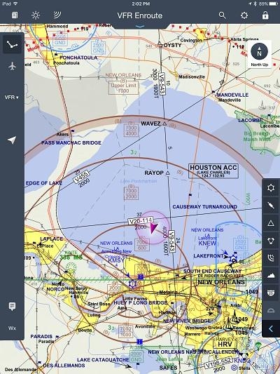
Jeppesen recently introduced new features for Mobile FliteDeck version 2.7 to enhance situational awareness and provide data for both IFR and VFR flying conditions. A new VFR theme provides general and business aviation pilots with the ability to switch between IFR and VFR data on the real time, data-driven enroute map. The ability to import route information and third-party flight planning data is also now available, and the iPad-based electronic flight bag (EFB) solution is also compliant with the iOS 9 operating system.

“This new mobile EFB functionality allows pilots to integrate planning data from multiple resources and fly with the data most relevant to current flying conditions. This enhances both the planning and flying experience,” said Mike Abbott, director, Jeppesen Navigation & Flight Deck Programs. “Our new version of Mobile FliteDeck on iPad is optimized for iOS 9, to improve the user experience under the latest operating system.”

Jeppesen says the ability to switch between IFR and VFR flight data allows pilots to easily transition to the flight information needed while flying under both instrument and visual flight rule conditions. The new route and flight planning data import capabilities provides access to essential information from multiple sources, including third-parties, to establish a single resource for managing the planning and operation of flights. Flight planning data may now be integrated into Mobile FliteDeck from sources including AvPlan, FltPlan.com and RocketRoute apps.

Mobile FliteDeck also now allows pilots to view which origin and destination airport pairs have been cleared by air traffic control in the past 24 hours. Determination of routes based on this knowledge will help pilots plan flights more efficiently, especially in congested airspace.

Additionally, new in-app search capabilities now help pilots discover features and user support information. According to Jeppesen, these enhancements create greater pilot control of information display and configuration of Mobile FliteDeck elements based on user preferences, to simplify the flying experience.

The new capabilities introduced with Mobile FliteDeck version 2.7 add to recent enhancements, including the ability for pilots to create, load, view, and save active flight data from either the terminal charts view or the enroute view. Device-to-device sharing of routes, Navaids, waypoints, (including user-defined waypoints) and airways also has been recently added.

Jeppesen says the use of Mobile FliteDeck eliminates paper-based flight materials to increase fuel efficiency and streamlines the entire flight process, allowing pilots to focus on essential flying tasks instead of managing technology. Mobile FliteDeck also includes enroute weather data display for icing, turbulence, winds aloft, radar and surface observations.

(Image provided by Jeppesen)

FMI: www.jeppesen.com/mobile

Advertisement

More News

Unfortunate... ANN/SportPlane Resource Guide Adds To Cautionary Advisories

The Industry Continues to be Rocked By Some Questionable Operations Recent investigations and a great deal of data has resulted in ANN’s SportPlane Resource Guide’s rep>[...]

ANN FAQ: Turn On Post Notifications

Make Sure You NEVER Miss A New Story From Aero-News Network Do you ever feel like you never see posts from a certain person or page on Facebook or Instagram? Here’s how you c>[...]

ANN's Daily Aero-Term (04.29.24): Visual Approach Slope Indicator (VASI)

Visual Approach Slope Indicator (VASI) An airport lighting facility providing vertical visual approach slope guidance to aircraft during approach to landing by radiating a directio>[...]

ANN's Daily Aero-Term (04.28.24): Airport Marking Aids

Airport Marking Aids Markings used on runway and taxiway surfaces to identify a specific runway, a runway threshold, a centerline, a hold line, etc. A runway should be marked in ac>[...]

ANN's Daily Aero-Linx (04.28.24)

Aero Linx: The Skyhawk Association The Skyhawk Association is a non-profit organization founded by former Skyhawk Pilots which is open to anyone with an affinity for the A-4 Skyhaw>[...]

blog comments powered by Disqus


Advertisement

Advertisement

Podcasts

Advertisement

© 2007 - 2024 Web Development & Design by Pauli Systems, LC