Tue, Sep 15, 2020
Worse... Wildfires Spew Methanol, Benzene, Ozone And Other Noxious Chemicals
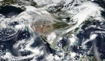
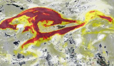
NOAA/NASA's Suomi NPP satellite captured two recent images of the United States and both images show that the winds have changed yet again, blowing the smoke from western fires back to the East and crossing the continental U.S. Along with the smoke, small particles suspended in the air (aerosols) are also moved along the jet stream and bring hazardous air quality across the country.
The image on the left shows the entire United States and the shroud of smoke that hangs over the majority of it. The image to the right shows the aerosols that accompany that smoke. Aerosols are a mixture of small particles and chemicals produced by the incomplete burning of carbon-containing materials such as trees, grasses, peat, brush, etc.
All smoke contains carbon monoxide, carbon dioxide and particulate matter (PM or soot). The smaller the particles, the easier they are to be inhaled and absorbed into the lungs. From the EPA website: "The biggest health threat from smoke is from fine particles. These microscopic particles can penetrate deep into your lungs. They can cause a range of health problems, from burning eyes and a runny nose to aggravated chronic heart and lung diseases. Exposure to particle pollution is even linked to premature death."
A study was published in Nature Geoscience in May 2017 which discovered that particle pollution from wildfires, long known for containing soot and other fine particles known to be dangerous to human health, is much worse than previously thought. Naturally burning timber and brush from wildfires release dangerous particles into the air at a rate three times as high as levels known by the EPA, researchers at Georgia Tech found. The study also found wildfires spew methanol, benzene, ozone and other noxious chemicals. Residents that smell smoke or see haze in the air should take precautions against breathing too much of it and stay tuned to local air quality information.
NASA's Earth Observing System Data and Information System (EOSDIS) Worldview application provides the capability to interactively browse over 700 global, full-resolution satellite imagery layers and then download the underlying data. Many of the available imagery layers are updated within three hours of observation, essentially showing the entire Earth as it looks "right now.”
More News
Ultrahigh Frequency (UHF) The frequency band between 300 and 3,000 MHz. The bank of radio frequencies used for military air/ground voice communications. In some instances this may >[...]
During The 7 Second Descent, There Was Another TAWS Alert At Which Time The Engine Remained At Full Power On October 24, 2025 at 2115 mountain daylight time, a Cirrus SR22T, N740TS>[...]
From 2009 (YouTube Edition): Educational Organization Aims to Inspire by Sharing Tuskegee Story Founding leader Don Hinz summarized the Red Tail Project’s mission in simple, >[...]
“This feels like an important step since space travel for people with disabilities is still in its very early days... I’m so thankful and hope it inspires a change in m>[...]
Also: New Katanas, Kern County FD Training, IndiGo’s Botched Roster, MGen. Leavitt Named ERAU Dean The Australian Transportation Safety Bureau (ATSB) has wrapped up its inves>[...]
 ANN's Daily Aero-Term (12.19.25): Ultrahigh Frequency (UHF)

