Family Of Five Fatally Injured In California Accident
A Piper PA-32RT Turbo Lance with five people on board apparently broke up in flight while the pilot was transitioning from VFR to IFR flight, though FAA records indicate he did not have an instrument rating for his private pilot certificate.

According to the preliminary report, on December 19, 2015, at 1556 PST, the Piper PA-32RT-300T, N36402, impacted terrain following an in-flight breakup near Bakersfield, CA. The airplane was registered to RAD Aviation LLC, and operated by the private pilot under the provisions of 14 Code of Federal Regulations Part 91. The pilot and four passengers sustained fatal injuries; the airplane was destroyed during the accident sequence. The cross-country flight departed Reid-Hillview Airport of Santa Clara County, San Jose, California, at 1435, with a planned destination of Henderson Executive Airport, Las Vegas, Nevada. Instrument meteorological conditions prevailed, and an instrument flight rules (IFR) flight plan had been filed.
The pilot, however, held a private pilot certificate with ratings for airplane single-engine land issued in July 2012. He did not hold an instrument rating. Review of his flight logbook revealed a total flight experience of 269.5 hours as of December 9, 2015. He documented 3.1 hours of simulated instrument time as part of his training for the private certificate in 2012, along with 0.8 hours of flight experience in actual instrument conditions during two IFR training flights in February 2014; these two flights were his only documented actual IFR experience, according to the FAA.
Preliminary radar and audio data provided by the FAA revealed that the airplane departed San Jose, and initiated a climb to the southeast. The flight had been assigned a squawk code, and was receiving visual flight rules (VFR) flight following. During the initial climb the pilot was provided traffic advisories from SoCal and then NorCal Approach, and reported that he would like to climb to 15,500 ft to stay above clouds. As the flight progressed, NorCal Approach began issuing advisories and vectors to aircraft in the San Jose area for a 10- to 15-mile-wide band of moderate to heavy precipitation. At 1502, the pilot made contact with Oakland Approach, and the airplane began to track south, leveling off at a mode C reported altitude of 15,500 ft. Ten minutes later the airplane began climbing, coincident to a commercial airplane (SkyWest 2955) approaching and descending 4 miles from the east at an altitude of 17,700 ft for an approach to Monterey Regional Airport. The controller received a conflict
alert, and the pilot of the commercial airplane reported they were initiating a climb because their traffic collision avoidance system (TCAS) had issued a resolution advisory (RA). The controller advised N36402 of the traffic conflict, requested that he maintain VFR, and asked if he was climbing. The pilot reported that he was "going to climb over the top of this (unreadable)," and reported that he would level off at 16,500 ft.
At 1516, the pilot requested a climb to 17,500 ft and direct route to Paso Robles, California. The airplane then abruptly turned east, and 5 minutes later began an arcing right turn towards the south in the direction of Paso Robles. About that time, the controller issued an advisory to VFR traffic for moderate to heavy precipitation south of the Panoche VOR, which was about 40 miles north of N36402, in the region of its earlier flight leg. At 1524, having reached Paso Robles, N36402 began a turn to the east, with the pilot reporting that he was turning towards Bakersfield. The airplane was then transferred to the control of Los Angeles Center. The airplane continued on track towards Bakersfield, and at 1537, about 55 miles west-northwest of Bakersfield, the controller relayed, "moderate precipitation from one to two o'clock to your 9 o'clock position, first group of cells begins in about 5 miles, and then there is a secondary line from north to south that begins in about two zero miles and extends one
five miles." The pilot reported that he could see the clouds and would be watching them. Three minutes later he reported that he would be descending to 15,500 ft and shortly thereafter, the pilot of a Cessna 414 reported that he was over the Shafter VOR, and the cloud tops were at 18,000 ft. The pilot of N36402 asked for clarification of the Cessna's location, and the controller advised it was 30 miles to the east. The pilot responded, "Roger, just wondering when I can get over to their altitude and clear the clouds." The controller again alerted the pilot to areas of moderate to heavy precipitation along his route of flight, and the pilot asked if the controller knew how high the bottoms of the clouds were; the controller responded that he did not have that information, but was aware of light rime icing up to 19,000 ft to the southeast. The pilot responded, "Ok, we're going to deviate to the south and try and go through Barstow." Another airplane then reported cloud tops in the Palmdale area of about
21,000 ft and the controller reiterated this information to N36402, advising that it was in the direction that he was heading. The pilot responded, and the controller then provided another weather update, which indicated areas of moderate precipitation at the 11 to 2 o'clock position.

At 1550, the controller asked if the pilot would like to file an IFR clearance to Henderson. The pilot responded in the affirmative, requesting an altitude of 15,000 ft. Two minutes later the airplane began a left turn to the north, and a short time later the controller advised he was ready with the IFR clearance. The controller provided the clearance, and the pilot read it back; however, the airplane had now transitioned to a northeast track. The controller asked if the pilot was turning northbound, and the pilot stated, "Roger, I just took a heading off of Bakersfield and I'm going to change it to the current IFR." The controller then asked the pilot twice without response to turn 10 degrees right to avoid traffic, followed by a request to fly a heading of 095. The pilot responded, however, rather than turning right, the airplane began a climbing left turn to 315 degrees reaching an altitude of 15,600 ft, 40 seconds later. The controller then asked the pilot to make an immediate right turn to 095,
however, by this time the airplane had now descended to 13,800 ft and was on an eastbound track. A few seconds later the pilot reported, "air traffic control Lance 402 mayday mayday mayday," followed 20 seconds later by another mayday call. The controller provided vectors to Bakersfield, however, no response was received, and 10 seconds later at 1556:10, the last radar target was recorded indicating the airplane was at an altitude of 11,200 ft. The controller asked multiple aircraft in the vicinity if they could see or contact N36402, however, they responded negative, with one pilot reporting that the area was enveloped in clouds.
The airplane had fragmented in flight, with the majority of the components coming to rest in an almond orchard, directly below the last radar target, about 9 miles southwest of Bakersfield. The orchard was at an elevation of 345 ft msl, and the debris field was 1/2 mile long and 700 ft wide, on a north-south orientation. The engine and forward cabin were located in an irrigation ditch at the southernmost point of the field. Cabin seats, baggage, and the vertical stabilizer were located about 800 ft north, with both wings and multiple cabin roof fragments a further 400 ft downrange. Debris consisting of shredded sections of cabin sheet metal and both the left and right side of the stabilator were located a further 700 ft north; the left aileron was the last component in the path. All primary airframe and flight control components were accounted for at the site.
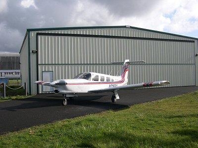
(File image released to Public Domain via Wikipedia. Not accident airplane)
 Airborne 04.16.24: RV Update, Affordable Flying Expo, Diamond Lil
 ANN's Daily Aero-Term (04.20.24): Light Gun
 Aero-News: Quote of the Day (04.20.24)
 Aero-News: Quote of the Day (04.21.24)
 ANN's Daily Aero-Term (04.21.24): Aircraft Conflict


