FAA Regs Slowing Drone Use For Wildfire Surveillance | Aero-News Network
Aero-News Network
RSS icon RSS feed
podcast icon MP3 podcast
Subscribe Aero-News e-mail Newsletter Subscribe

Airborne Unlimited -- Most Recent Daily Episodes

Episode Date

Airborne-Monday

Airborne-Tuesday

Airborne-Wednesday Airborne-Thursday

Airborne-Friday

Airborne On YouTube

Airborne-Unlimited-05.13.24

Airborne-NextGen-05.14.24

Airborne-Unlimited-05.15.24 Airborne-AffordableFlyers-05.16.24

Airborne-Unlimited-05.17.24

Tue, May 28, 2013

FAA Regs Slowing Drone Use For Wildfire Surveillance

Aircraft Being Evaluated In The Western U.S. For Public Safety Use

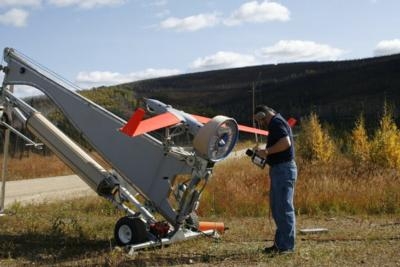
The U.S. Forest Service is exploring the use of UAVs to track how wildfires spread and identify hotspots using infrared cameras, all in an effort  to reduce risks to pilots, firefighters, and others on the ground in a fire's path. But the Forest Service says the FAA is severely limiting their ability do make those evaluations.

According to current FARs, UAVs may not operate out of sight of a ground-based pilot. That's difficult in situations where smoke severely reduces visibility, and so a piloted aircraft must be dispatched to watch the drone. 

According to a story in the New York Times, the Forest Service says that UAVs were used successfully help track a wildfire in Alaska nearly four years ago that generated so much thick smoke that manned flights were prohibited. A University of Fairbanks UAV was used to help track where the fire was heading, and where it was generating the most heat. But getting permission for that flight took four days. The fire eventually burned nearly half a million acres. Kent Slaughter, the acting manager of the Bureau of Land Management’s Alaska Fire Service, now says the process takes about 24 hours.

Alaska Senator Mark Begich (D) has called the delays in getting approval for testing and evaluation "frustrating," but the FAA says that safety both in the air and on the ground is the agency's primary consideration.

(U.S. Forest Service photo)

FMI: www.fs.fed.us, www.faa.gov

Advertisement

More News

ANN's Daily Aero-Term (05.17.24): Very High Frequency

Very High Frequency The frequency band between 30 and 300 MHz. Portions of this band, 108 to 118 MHz, are used for certain NAVAIDs; 118 to 136 MHz are used for civil air/ground voi>[...]

ANN's Daily Aero-Linx (05.17.24)

Aero Linx: Aviation Suppliers Association Established February 25, 1993, the Aviation Suppliers Association (ASA), based in Washington, D.C., is a not-for-profit association, repre>[...]

ANN FAQ: Submit a News Story!

Have A Story That NEEDS To Be Featured On Aero-News? Here’s How To Submit A Story To Our Team Some of the greatest new stories ANN has ever covered have been submitted by our>[...]

Classic Aero-TV: ANN Visits Wings Over The Rockies Exploration Of Flight

From 2021 (YouTube Version): Colorado Campus Offers aVariety Of Aerospace Entertainment And Education Wings over the Rockies Exploration of Flight is the second location for the Wi>[...]

Airborne Affordable Flyers 05.16.24: PRA Runway, Wag-Aero Sold, Young Eagles

Also: Paramotor Champ's, Electric Ultralight, ICON BK Update, Burt Rutan at Oshkosh! The Popular Rotorcraft Association is reaching out for help in rebuilding their private runway >[...]

blog comments powered by Disqus


Advertisement

Advertisement

Podcasts

Advertisement

© 2007 - 2024 Web Development & Design by Pauli Systems, LC