Arcturus UAV And Urban Robotics Fly 3-D Imager | Aero-News Network
Aero-News Network
RSS icon RSS feed
podcast icon MP3 podcast
Subscribe Aero-News e-mail Newsletter Subscribe

Airborne Unlimited -- Most Recent Daily Episodes

Episode Date

Airborne-Monday

Airborne-Tuesday

Airborne-Wednesday Airborne-Thursday

Airborne-Friday

Airborne On YouTube

Airborne-Unlimited-11.24.25

AirborneNextGen-
11.18.25

Airborne-Unlimited-11.19.25

Airborne-AffordableFlyers-11.20.25

AirborneUnlimited-11.21.25

LIVE MOSAIC Town Hall (Archived): www.airborne-live.net

Tue, Jan 28, 2014

Arcturus UAV And Urban Robotics Fly 3-D Imager

Device Can Create 3-D Images In Near-Real Time, Maker Says

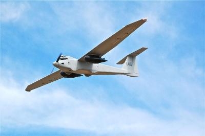
A sensor system designed to create 3-D reconstructions in near-real time and output high-resolution digital elevation models, LIDAR-like datasets, and wide area maps has been flown on an Arcturus UAV T-20 Tier II unmanned aerial vehicle. The system, called GeoDragon, is enclosed in a wing-mounted pod and is capable of high resolution 2-D and 3-D image capture.

Urban Robotics in Portland, OR, which designed the sensor, says among its "unique aspects" are low weight (equating to longer endurance and loiter time,) small operational footprint on the ground (1 or 2 full size pick-up trucks,) a quick mount/dismount pod, quiet operation (the T-20 utilizes a modified 4-stroke engine,) and the ability to fly simultaneously with other payloads on the T-20, such as EO/IR.

GeoDragon imagery is post-processed using automated 3-D algorithms to rapidly generate large mapping and modeling datasets. Urban Robotics develops software and hardware solutions for 3-D ISR, remote sensing and geospatial applications, including collection, post-processing, and data management. 

The aircraft was built by Arcturus UAV in Rohnert Park, CA. Urban Robotics says the GeoDragon adds significant 3-D imaging and mapping capabilities to the T-20 UAV. The system is scheduled to be released in mid-2014.

(Image provided by Arcturus)

FMI: www.arcturus-uav.com

Advertisement

More News

Classic Aero-TV: Pure Aerial Precision - The Snowbirds at AirVenture 2016

From 2016 (YouTube Edition): The Canadian Forces Snowbirds Can Best Be Described As ‘Elegant’… EAA AirVenture 2016 was a great show and, in no small part, it was>[...]

NTSB Final Report: Costruzioni Aeronautiche Tecna P2012 Traveller

Airplane Lunged Forward When It Was Stuck From Behind By A Tug That Was Towing An Unoccupied Airliner Analysis: At the conclusion of the air taxi flight, the flight crew were taxii>[...]

ANN's Daily Aero-Linx (11.23.25)

Aero Linx: International Stinson Club So you want to buy a Stinson. Well the Stinson is a GREAT value aircraft. The goal of the International Stinson Club is to preserve informatio>[...]

ANN's Daily Aero-Term (11.23.25): Request Full Route Clearance

Request Full Route Clearance Used by pilots to request that the entire route of flight be read verbatim in an ATC clearance. Such request should be made to preclude receiving an AT>[...]

Aero-News: Quote of the Day (11.23.25)

"Today's battlefield is adapting rapidly. By teaching our soldiers to understand how drones work and are built, we are giving them the skills to think creatively and apply emerging>[...]

blog comments powered by Disqus


Advertisement

Advertisement

Podcasts

Advertisement

© 2007 - 2025 Web Development & Design by Pauli Systems, LC