New Features Help In Preflight Planning, Flight, And Logging
ForeFlight has released version 8.3, the first major update of the popular flight planning app for 2017. The company has posted information on its website to explain some of the new features included in the update.
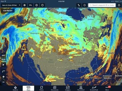
ForeFlight got its start as a preflight weather utility, and the latest release continues to expand the app’s weather offerings. The latest addition is a new satellite weather overlay for the Maps screen that weather geeks will surely love. The new Color IR Satellite option can be found in the map overlay drop-down menu. This is a second satellite layer that complements the existing satellite overlay, which is now called Enhanced Satellite.
This worldwide weather layer uses infrared images to show cloud temperatures, which typically decrease with altitude (the blue areas on the layer are the coldest). This can be useful when flying during the colder months to help identify areas that contain supercooled liquid water and possible icing conditions. This phenomenon is likely to be present in the yellow and green areas, which are just warm enough to sustain supercooled water droplets.
While setting up your iPad in preparation for a night flight, make sure to check out the new night settings in the maps and plates section of the app. Look for a new option in map settings at the top called “Invert Chart Colors”. This will change any of the lighter colors on IFR en route chart or sectional to a dark color, and change black text to white, to help maintain a dark cabin and reduce eye strain.

Fortunately, the app only flips the white and black colors, so green, blue and magenta text isn’t affected. There is more of a color shift on the background shading when inverting the sectional charts colors, which will take some time to get used to. And remember, the dark theme of ForeFlight’s custom aeronautical charts can always be used for an improved night experience.
A similar option is available when viewing the plates section of the app at the top left of the screen, called Invert Plate Colors. This will apply the same color shift to approach plates and airport diagrams for improved night viewing.
When viewing plates on maps with the colors inverted on both chart types, the approach plate will be slightly brightened so that is stands out against the IFR chart.
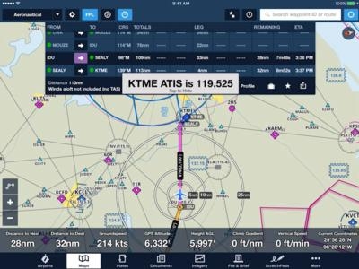
To help reduce heads-down time in the cockpit while preparing for arrival, ForeFlight will display the weather frequency (ATIS, ASOS or AWOS) for the destination airport when 20 miles out in a pop-up message on the screen. The alert includes spoken audio of the weather frequency and it will remain on the screen until you tap it.
Pilots flying with the new SiriusXM SXAR1 aviation receiver have two new map overlay layers to display on the map in flight: Echo Tops and Cloud Tops.
The cloud tops layer includes a slider at the bottom right of the map screen that allows you to filter out clouds at lower altitudes. Tops above 25,000 ft MSL are color-coded using blue, orange and red to visually enhance the highest tops. Tops below 25,000 ft are shown as simple shades of gray.
The echo tops layer shows a graphical view of the highest altitude where ground-based radar detects precipitation returns above the 18dBz intensity threshold. 18dBZ is normally shown as dark blue on a normal radar return. This represents the core of the precipitation in a storm or weather system and can be used to help determine the intensity of the system. Keep in mind that this is measuring the top of the precipitation, so there will likely be cloud layers above the depicted altitude.
IFR departure procedures define required climb gradients in feet per nautical mile, and then it’s up to you to determine that your airplane can meet this performance minimum based on your airplane’s capabilities that day. During flight planning, this ft/NM requirement and planned groundspeed are used to determine the required climb rate in feet per minute.
ForeFlight can help shed a little more light on how your climb is actually progressing with a new Climb Gradient Instrument on the maps page. This uses GPS, groundspeed, and vertical speed information to display your climb gradient in feet per nautical mile, allowing you to monitor your climb performance in real time. Activate this new instrument by tapping on the Instrument Panel and selecting Climb Gradient from the list.
ForeFlight continues to enhance the flight logging process to make it as effortless as possible by monitoring each flight and autofilling data.
Recent airplanes: when you go to add a specific aircraft to a log entry, ForeFlight will automatically show the most recently used aircraft N#s at the top of the list.
Instrument approaches: the logbook autofills the destination airport and shows a list of approaches for quick entry.
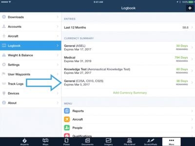
Add currency tracking for multiple aircraft types: the currency summary will now track day and night currency by aircraft type, which is useful for those who need to maintain a certain level of currency in a specific type of aircraft. Tap “add currency summary” from the main logbook screen, select the new option “aircraft type currency” and choose the aircraft types you’d like to track. A dedicated listing will be displayed in the Currency Summary for the selected aircraft type.
The last new feature in ForeFlight 8.3 is a fun one that allows you to better share your flight logs and photos with family and friends. At the bottom of each logbook entry is a new button labeled “View Entry Summary”. This prepares a nicely-formatted screen with the flight path on an interactive map, flight details and attached photos from the flight. You can use the “send-to” button at the top right of the screen to share via social media or email a link for others to view the flight summary in a web browser.
(Images provided by ForeFlight)
 ANN's Daily Aero-Term (10.02.25): Radar Contact Lost

