 NOTAM Number: FDC 8/4632
Issue Date: June 26, 2008 at 2059 UTC
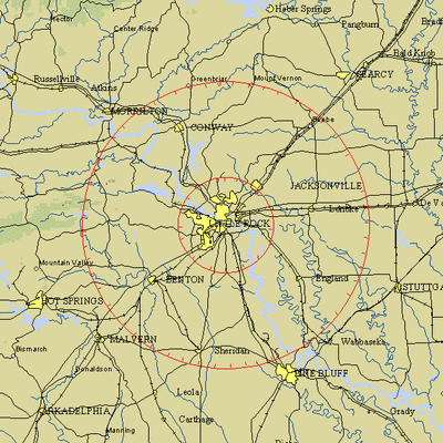
Location: Little Rock, Arkansas
Beginning Date and Time: July 01, 2008 at 1935 UTC
Ending Date and Time: July 01, 2008 at 2355 UTC
Reason for NOTAM: Temporary flight restrictions for VIP (Very
Important Person) Movement
Type: VIP
Replaced NOTAM(s): 8/4561: Due to change in Times
Affected Area(s)
Area A
Airspace Definition:
Center: On the LITTLE ROCK VORTAC (LIT) 311 degree radial at
5.9 nautical miles. (Latitude: 34º44'53"N, Longitude:
92º15'46"W)
Radius: 30 nautical miles
Altitude: From the surface up to but not including 18000 feet
MSL
Effective Date(s):
From July 01, 2008 at 1935 UTC (July 01, 2008 at 1435
CDT)
To July 01, 2008 at 2355 UTC (July 01, 2008 at 1855 CDT)
Area B
Airspace Definition:
Center: On the LITTLE ROCK VORTAC (LIT) 311 degree radial
at 5.9 nautical miles. (Latitude: 34º44'53"N, Longitude:
92º15'46"W)
Radius: 10 nautical miles
Altitude: From the surface up to but not including 18000 feet
MSL
Effective Date(s):
From July 01, 2008 at 1935 UTC (July 01, 2008 at 1435
CDT)
To July 01, 2008 at 2355 UTC (July 01, 2008 at 1855 CDT)
Operating Restrictions and Requirements
No pilots may operate an aircraft in the areas covered by this
NOTAM (except as described).
Except as specified below and/or unless authorized by ATC in
consultation with the air traffic security coordinator via the
domestic events network (DEN):
A. All aircraft operations within the 10 NMR area(s) listed
above, known as the inner core(s), are prohibited except for:
Approved law enforcement, military aircraft directly supporting the
United States Secret Service (USSS) and the office of the President
of the United States, approved emergency medical flights, and
regularly scheduled commercial passenger and all-cargo carriers
operating under one of the following TSA-Approved standard security
programs/procedures: aircraft operator standard security program
(AOSSP), full all-cargo aircraft operator standard security program
(FACAOSSP), model security program (MSP), twelve five standard
security program (TFSSP) all cargo, or all-cargo international
security procedure (ACISP) and are arriving into and/or departing
from 14 cfr part 139 airports.
B. For operations within the airspace between the 10 NMR and 30
NMR area(s) listed above, known as the outer ring(s): All aircraft
operating within the outer ring(s) listed above are limited to
aircraft arriving or departing local airfields, and workload
permitting, ATC may authorize transit operations. Aircraft may not
loiter. All aircraft must be on an active IFR or VFR flight plan
with a discrete code assigned by an air traffic control (ATC)
facility.
C. For operations within this TFR, all USSS vetted aircraft
operators based in the area and all emergency/life saving flight
(medical/law enforcement/firefighting) operations must coordinate
with ATC prior to their departure at 501-379-2908 to avoid
potential delays.
D. The following operations are not authorized within this TFR:
flight training, practice instrument approaches, aerobatic flight,
glider operations, parachute operations, ultralight, hang gliding,
balloon operations, agriculture/crop dusting, animal population
control flight operations, banner towing operations, model aircraft
operations, model rocketry, and unmanned aerial systems (USA).
E. FAA recommends that all aircraft operators check notams
frequently for possible changes to this TFR prior to operations
within this region.
Other Information:
ARTCC: ZME - Memphis Center
Authority: Title 14 CFR section 91.141
FMI: www.tfr.faa.gov,
Depicted TFR data may not be a complete listing. Pilots should not
use the information on this website for flight planning purposes.
For the latest information, call your local Flight Service Station
at 1-800-WX-BRIEF.
 Unfortunate... ANN/SportPlane Resource Guide Adds To Cautionary Advisories

