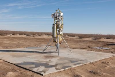
ADAPT System Flown On Masten Xombie Platform
It's tricky to get a spacecraft to land exactly where you want. That's why the area where the Mars rover Curiosity team had targeted to land was an ellipse that may seem large, measuring 12 miles by 4 miles.

Engineers at NASA's Jet Propulsion Laboratory in Pasadena, CA have been developing cutting-edge technologies that would enable spacecraft to land at a specific location on Mars -- or any other planetary body -- with more precision than ever before. In collaboration with Masten Space Systems in Mojave, CA they have recently tested these technologies on board a high-tech demonstration vehicle called the Autonomous Descent and Ascent Powered-flight Testbed (ADAPT).
ADAPT is a test system built on Masten's XA-0.1B "Xombie" vertical-launch, vertical-landing reusable rocket. The Xombie platform provides a good approximation of Mars-like descent conditions through high-speed descent rates at low altitudes. Those conditions are difficult to achieve through conventional flight test platforms. Onboard this rocket, two sophisticated lander technologies were recently tested: Terrain Relative Navigation with a sensor called the Lander Vision System (LVS), and the Guidance for Fuel-Optimal Large Diverts (G-FOLD) algorithm. "No previous Mars lander has used onboard surface imaging to achieve a safe and precise touchdown, but a future spacecraft could use LVS and G-FOLD to first autonomously determine its location and then optimally fly to its intended landing site," said Nikolas Trawny, ADAPT's principal investigator at JPL. "All of this happens on board, without human intervention, and in real time."
ADAPT had two successful test flights, one on Dec. 4, 2014, and the second on Dec. 9. In both cases, the rocket reached a maximum altitude of 1,066 feet before beginning its descent.
The terrain-relative navigation capability provided by LVS allows Xombie to precisely determine its position without requiring GPS. To do so, ADAPT first takes a series of pictures of the terrain below it during descent. These pictures are then compared to an image of the terrain stored onboard, allowing the vehicle to autonomously find its position relative to the landing site. The spacecraft can then use this information to correct its course to get as close to the targeted landing site as possible within its capability, and make a smooth, pinpoint landing.

G-FOLD is an algorithm, developed at JPL and at the University of Texas at Austin, that calculates the optimal path to divert a spacecraft to a target landing site in real time. For the first time, G-FOLD allows onboard calculation of divert trajectories that obtain the maximum performance from every kilogram of propellant.
The combination of LVS and G-FOLD allowed the Xombie rocket to begin to change the course of its descent at about 623 feet in the air on December 9. The rocket then flew the newly calculated course to successfully reach the target landing pad located 984 feet to the east.
"This represents a huge step forward in our future capabilities for safe and precise Mars landing, and demonstrates a highly effective approach for rapid, low-cost validation of new technologies for the entry, descent and landing of spacecraft," said Chad Edwards, chief technologist of the Mars Exploration Directorate at JPL. "This same technology has valuable applications to landing on the moon, asteroids and other space targets of interest."
(Images provided by NASA)
 ANN's Daily Aero-Term (12.19.25): Ultrahigh Frequency (UHF)

