UAS Gives Scientists 3D View Of Atmosphere | Aero-News Network
Aero-News Network
RSS icon RSS feed
podcast icon MP3 podcast
Subscribe Aero-News e-mail Newsletter Subscribe

Airborne Unlimited -- Most Recent Daily Episodes

Episode Date

Airborne-Monday

Airborne-Tuesday

Airborne-Wednesday Airborne-Thursday

Airborne-Friday

Airborne On YouTube

Airborne-Unlimited-10.27.25

AirborneNextGen-
10.28.25

Airborne-Unlimited-10.29.25

Airborne-FltTraining-10.23.25

AirborneUnlimited-10.17.25

Mon, Jan 11, 2010

UAS Gives Scientists 3D View Of Atmosphere

Trio Of Aircraft Used In Climate Research

Scientists at Scripps Institution of Oceanography at UC San Diego have been using a fleet of Manta autonomous UAVs to track pollution and atmospheric data over the skies of Southern California.  The California AUAV Air Pollution Profiling Study (CAPPS) program is the latest in a series of science missions using UAS around the world.

The CAPPS began data collection on April 2, gathering a suite of meteorological data as they fly through clouds and aerosol masses in Southern California skies. When flying in formation, the aircraft can provide researchers with a unique three-dimensional view of atmospheric composition.

Miniaturized instruments on the aircraft, which typically flew in formations of three, measured a range of properties such as the quantity and size of the aerosols on which cloud droplets form. The instruments also recorded variables such as temperature, humidity and the intensity of light that permeates clouds and masses of smog. These comprehensive measurements were made at a very low cost when compared to traditional manned flights.


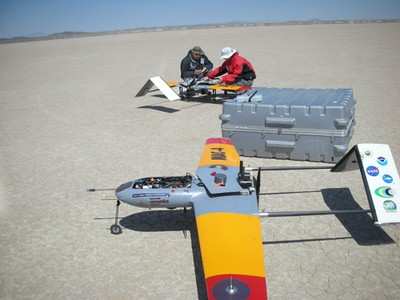
Technicians prepare the Manta for launch at Edwards AFB.

The Manta is one of several UAS produced by Advanced Ceramics Research in Tucson, AZ, now a part of BAE Systems.  Manta can carry a 15-lb payload for up to 6 hrs with a typical service altitude of 2,000-12,000 ft.  The aircraft have been deploying from NASA's Dryden Flight Research Center at Edwards AFB

Scripps researches hope to fly the system at least once a month to monitor Southern CA skies.  Future applications include real-time situational awareness during forest fires.

FMI: www.ARCTucson.com, sio.ucsd.edu

Advertisement

More News

Aero-News: Quote of the Day (10.27.25)

“In recent years, park officials have observed a rise in illegal drone activity, which they attribute to the increasing affordability and availability of consumer drones. In >[...]

ANN's Daily Aero-Linx (10.27.25)

Aero Linx: Aeronautical Repair Station Association (ARSA) ARSA is devoted to the worldwide civil aviation maintenance industry—from its global corporations to the small, inde>[...]

NTSB Prelim: Lancair 320

During Cruise Flight At 4,500 Ft, The Engine Stopped Producing Power Without Any Warning On October 4, 2025, about 2130 central daylight time, a Lancair 320 airplane, N431M, was de>[...]

Airborne Programming Continues Serving SportAv With 'Airborne-Affordable Flyers'

With The eSPRG Only Weeks Away From Its Start Date, A-AF Will Help To Support Sport Flyers, Worldwide With the all-new and all-digital SportPlane Resource Guide getting ready for p>[...]

Airborne-Flight Training 10.23.25: PanAm Back?, Spirit Cuts, Affordable Expo

Also: USAF Pilots, Advanced Aircrew Academy, ATC Hiring, Hop-A-Jet Sues Pan American is attempting a comeback. Aviation merchant bank AVi8 Air Capital, alongside Pan American Globa>[...]

blog comments powered by Disqus


Advertisement

Advertisement

Podcasts

Advertisement

© 2007 - 2025 Web Development & Design by Pauli Systems, LC