USAF's Global Hawk Continues Reconnaissance In Haiti | Aero-News Network
Aero-News Network
RSS icon RSS feed
podcast icon MP3 podcast
Subscribe Aero-News e-mail Newsletter Subscribe

Airborne Unlimited -- Most Recent Daily Episodes

Episode Date

Airborne-Monday

Airborne-Tuesday

Airborne-Wednesday Airborne-Thursday

Airborne-Friday

Airborne On YouTube

Airborne-Unlimited-04.29.24

Airborne-Unlimited-04.23.24

Airborne-Unlimited-04.24.24 Airborne-FltTraining-04.25.24

Airborne-Unlimited-04.26.24

Tue, Feb 16, 2010

USAF's Global Hawk Continues Reconnaissance In Haiti

Capturing Thousands Of Images Of Earthquake Damage

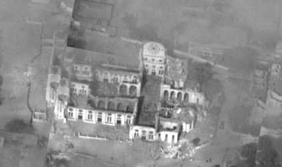
A U.S. Air Force RQ-4 Global Hawk continues its persistent watch over Haiti. To date, the Global Hawk has flown six missions, approximately 130 hours, and provided more than 3,600 images of Port-au-Prince and areas damaged by the massive earthquake and ensuing aftershocks that rocked the Caribbean nation earlier this year.

Global Hawk Aerial Photo

"Thanks to Global Hawk's highly advanced sensors, which are capable of taking hundreds of images in a single mission, we've provided disaster assessments for various agencies to make real-time decisions," said Gen. Bob Otto, commander of the 9th Reconnaissance Wing, Beale Air Force Base, CA. "The ability to fly 24-hour duration sorties meant the Global Hawk could support hundreds of ad-hoc requests while staying well clear of the relief workers and neighboring airports. Truly, Global Hawk's capabilities have proven invaluable to the worldwide humanitarian efforts in Haiti."

On January 13th, a U.S. Air Force Block 10 Global Hawk was diverted by the 12th Reconnaissance Squadron at Beale Air Force Base from its trip en-route to support usual wartime operations in Afghanistan to assist in relief efforts after Haiti's 7.0 magnitude earthquake on Jan. 12. A Global Hawk took off from its main operating base at Beale Air Force Base, flew to Haiti, and provided 12 hours of coverage over the disaster area before landing at Patuxent River Naval Air Station, MD. Subsequent missions were launched from Maryland to provide 14 to 16 hours of persistent watch over Haiti before landing back at Patuxent River.

"Not only has Global Hawk helped determine the extent of damages and usability of Haiti's infrastructure, it has also helped to find and recommend roadways and airfields accessible for delivering emergency supplies and rescuing injured and trapped people," said George Guerra, Northrop Grumman vice president of high-altitude, long-endurance systems. "We are committed to supporting the ongoing relief efforts in Haiti for as long as necessary to help rebuild the lives of those affected."

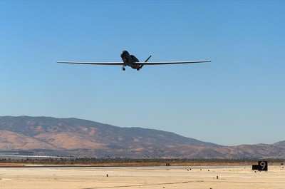
Global Hawk File Photo

The Global Hawk team collaborated with other agencies to assist in all aspects of recovery and relief. Officials and analysts from U.S. Southern Command in Miami, the 548th Intelligence, Surveillance and Reconnaissance (ISR) Group from Beale Air Force Base, the 480th ISR Wing from Langley Air Force Base, and the Naval Air Systems Command Broad Area Maritime Surveillance Demonstration program from Patuxent River helped provide critically needed imagery and information.

FMI: www.beale.af.mil

Advertisement

More News

Unfortunate... ANN/SportPlane Resource Guide Adds To Cautionary Advisories

The Industry Continues to be Rocked By Some Questionable Operations Recent investigations and a great deal of data has resulted in ANN’s SportPlane Resource Guide’s rep>[...]

ANN FAQ: Turn On Post Notifications

Make Sure You NEVER Miss A New Story From Aero-News Network Do you ever feel like you never see posts from a certain person or page on Facebook or Instagram? Here’s how you c>[...]

ANN's Daily Aero-Term (04.29.24): Visual Approach Slope Indicator (VASI)

Visual Approach Slope Indicator (VASI) An airport lighting facility providing vertical visual approach slope guidance to aircraft during approach to landing by radiating a directio>[...]

ANN's Daily Aero-Term (04.28.24): Airport Marking Aids

Airport Marking Aids Markings used on runway and taxiway surfaces to identify a specific runway, a runway threshold, a centerline, a hold line, etc. A runway should be marked in ac>[...]

ANN's Daily Aero-Linx (04.28.24)

Aero Linx: The Skyhawk Association The Skyhawk Association is a non-profit organization founded by former Skyhawk Pilots which is open to anyone with an affinity for the A-4 Skyhaw>[...]

blog comments powered by Disqus


Advertisement

Advertisement

Podcasts

Advertisement

© 2007 - 2024 Web Development & Design by Pauli Systems, LC