Thu, Jul 21, 2005
Rockwell Collins Completes Successful SE-Vision Test
Flights
 Rockwell Collins' SE-Vision program
has reached a new milestone by successfully completing military and
commercial test flights in New Mexico and New Jersey in June.
SE-Vision flight deck technology, which integrates synthetic vision
generated scenes with real-time enhanced vision imagery, is being
developed by Rockwell Collins in collaboration with the Federal
Aviation Administration (FAA), the Air Force Research Lab (AFRL),
NASA Langley Research Center and Max-Viz.
Rockwell Collins' SE-Vision program
has reached a new milestone by successfully completing military and
commercial test flights in New Mexico and New Jersey in June.
SE-Vision flight deck technology, which integrates synthetic vision
generated scenes with real-time enhanced vision imagery, is being
developed by Rockwell Collins in collaboration with the Federal
Aviation Administration (FAA), the Air Force Research Lab (AFRL),
NASA Langley Research Center and Max-Viz.
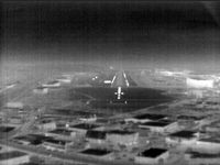 The SE-Vision program flight tests
demonstrated concepts for sensor and synthetic imagery for use by
the US Air Force's mobility operations in a low altitude tactical
environment. The flights were conducted through June on the FAA
William J. Hughes Technical Center's Boeing 727-100 which was
equipped with Rockwell Collins HGS-4000 Heads-Up Guidance System
(HGSTM), Max-Viz Dual Band Infrared Sensors, Rockwell Collins
MultiScan Hazard Weather Detection System and an LCD head-down
display (HDD). SE-Vision display and guidance concepts were shown
on both the HUD and the HDD.
The SE-Vision program flight tests
demonstrated concepts for sensor and synthetic imagery for use by
the US Air Force's mobility operations in a low altitude tactical
environment. The flights were conducted through June on the FAA
William J. Hughes Technical Center's Boeing 727-100 which was
equipped with Rockwell Collins HGS-4000 Heads-Up Guidance System
(HGSTM), Max-Viz Dual Band Infrared Sensors, Rockwell Collins
MultiScan Hazard Weather Detection System and an LCD head-down
display (HDD). SE-Vision display and guidance concepts were shown
on both the HUD and the HDD.
"SE-Vision provides a visualization solution for pilots who are
required to fly in low visibility conditions and unfamiliar
territory," said Tim Etherington, principal systems engineer at
Rockwell Collins Advanced Technology Center. "This technology can
have a major impact on the success of special operations missions
in the military, and provide promising opportunities for civil
aviation as well."
"The combination of synthetic vision and sensor technologies
will allow USAF mobility operations to operate independently of
visibility with improved situation awareness and safety," said Guy
French, SE-Vision Government Program Manager, AFRL.
 The demonstration flights took place
on a practice route used by Kirtland Air Force Base in New Mexico
for low level training. The routes used SE-Vision technology to
guide the aircraft through a mountain range at a pilot selected
altitude of 650 feet above the terrain for this flight test. Ten
Air Force pilots flew the terrain following path using SE-Vision
technology. A simulated version of the terrain following route was
demonstrated out of the William J. Hughes Technical Center in
Atlantic City, NJ.
The demonstration flights took place
on a practice route used by Kirtland Air Force Base in New Mexico
for low level training. The routes used SE-Vision technology to
guide the aircraft through a mountain range at a pilot selected
altitude of 650 feet above the terrain for this flight test. Ten
Air Force pilots flew the terrain following path using SE-Vision
technology. A simulated version of the terrain following route was
demonstrated out of the William J. Hughes Technical Center in
Atlantic City, NJ.
More News
Airport Rotating Beacon A visual NAVAID operated at many airports. At civil airports, alternating white and green flashes indicate the location of the airport. At military airports>[...]
Aero Linx: Fly for the Culture Fly For the Culture, Inc. is a 501(c)(3) non-profit organization that serves young people interested in pursuing professions in the aviation industry>[...]
Klyde Is Having Some Issues Comprehending The Fed's Priorities FMI: www.klydemorris.com>[...]
Also: Viasat-uAvionix, UL94 Fuel Investigation, AF Materiel Command, NTSB Safety Alert Norges Luftsportforbund chose Aura Aero's little 2-seater in electric trim for their next gli>[...]
Also: EP Systems' Battery, Boeing SAF, Repeat TBM 960 Order, Japan Coast Guard H225 Buy Despite nearly 100 complaints totaling millions of dollars of potential fraud, combined with>[...]
 ANN's Daily Aero-Term (04.25.24): Airport Rotating Beacon

