Goal Is To Allow Farmers To Make Better Growing Decisions
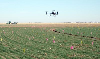
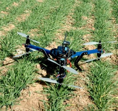
Dr. Charlie Rush hopes to use a unique method – a quadcopter – to track disease progression across wheat fields to eventually help producers make better irrigation decisions. A small UAV is being used by Dr. Rush, a Texas A&M AgriLife plant pathologist in Amarillo, to track disease progression across wheat fields. Rush has enlisted the help of Ian Johnson, a Montana State University-Bozeman graduate student who is using his work in the university’s Science and Natural History Filmmaking Program to help scientists conduct research.
Approximately 1.1 million acres of wheat in the High Plains are irrigated, Rush said, making wheat the second-largest user of irrigation water from the Ogallala Aquifer. In this same region, mite-vectored virus diseases are the predominant pathogenic constraint to sustainable wheat production each year. The viruses causing these diseases are transmitted by the wheat curl mite, he said. Infected wheat plants not only have reduced grain and forage yields, but also greatly reduced root weight and water-use efficiency. Therefore, fertilizer and groundwater applied as irrigation to diseased wheat is largely wasted.
Rush’s team is using the helicopter to take remote images of a field study where they are trying to develop an economic threshold for irrigation of wheat infected with wheat streak and other mite-vectored diseases. “The problem for farmers is that these diseases develop in gradients over time and they don’t know whether or not they should apply new pesticides or fertilizers or water,” he said. “Most of these practices are done in April, and that is when the disease is just starting to show up. They may know they have disease in the field, but they really don’t know how much damage it might cause.
“So what we are trying to do is be able to go in early in the season and look at the disease development at a particular time and then based on what it looks like, say in early April, be able to give them a prediction of what the crop will be at harvest time.”
To do that, Rush said his team has been going into the field using different types of remote imaging, such as the hand-held hyperspectral radiometer, to measure and quantify the severity of disease development in the field. A wedge image can be made after the aircraft has made about six passes over the field. The images it captures were stitched together by Ian Johnson, a Montana State University-Bozeman graduate student, for a complete picture.
“Now the application and use of this (aircraft) is one more way of measuring the disease development,” he said. “The beautiful thing about this is instead of having to deal with handheld devices, you can come in and fly the entire field in a matter of five minutes and get a very, very high resolution. So we are excited about the possibilities this may provide for our project.”
Johnson said he will use the quadcopter to make four or five flights during the growing season and then generate results that will help Rush. This Y6 helicopter, named for its Y shape and six propellers, is made by 3D Robotics and includes an autopilot. “That allows us to pre-program flights and fly a grid. As it is flying the grid, it takes top-down photos,” Johnson said. “Once we collect the photos, we stitch them together and build a giant photo mosaic of each field we flew over. We are hoping to provide incremental photo coverage of the fields as the disease progresses through the fields.”
Johnson said using this technology for agricultural research provides a whole list of improvements to the previous services available. Many researchers have used satellite imagery before, but this provides resolution 100 to 1,000 times greater than the LandSat satellite imagery Rush and his team used in the past. “That’s a huge improvement when you are looking at ground-coverage and trying to pick out diseased plants,” he said. “Another improvement is temporal resolution. We can fly this every day for a couple of weeks or every week for a whole season, whereas with satellite you have to wait two to three weeks for a pass and that is if you can get your slot. So this is a great improvement.”
Another thing, Johnson said, is the drone is currently using visible spectrum only – still photographs – because the project is focused on the yellow band of light, which easily captures the typical symptoms of wheat streak mosaic. “But this is a modular system,” he said. “We could put near infrared, thermal, any array of multi-spectral sensors on here to capture whatever data it is the project demands.”
Rush said one of the things he is most excited about with this new technology is that although aerial images have been taken before and unmanned aircraft have been used to measure things, “they have never been used to our knowledge to manage irrigation applications, especially in diseased crops. “This is something that is totally new,” he said. “Obviously, in the Texas Panhandle where water is such a precious resource, anything that we can do to reduce waste or farmers putting on irrigation water when it is not going to pay off for them is going to be a positive thing.”
Rush said he is confident that with the studies currently underway, this new technology will allow them to very quickly provide growers with the information they need to better manage their irrigation.
(Images by Key Ledbetter, Texas A & M)
 ANN's Daily Aero-Term (04.26.24): DETRESFA (Distress Phrase)

