Tue, Nov 24, 2009
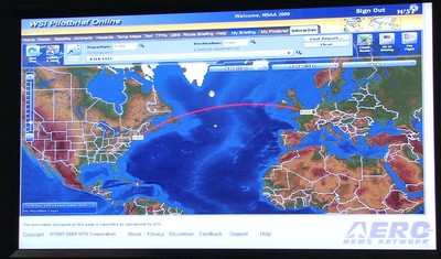
WSI Pilotbrief Online takes the award-winning WSI Pilotbrief
weather service suite and provides pilots immediate access to
up-to-date enhanced weather updates anywhere, anytime from any
Internet-enabled web browser. One of the few online weather
services with FAA Qualified Internet Communications Provider (QICP)
certification, Pilotbrief Online allows clients to file flight
plans directly to the FAA, as well as view their preferred routes
and briefing preferences at any of the numerous WSI Pilotbrief
kiosks located in FBO’s throughout the country.

Through Pilotbrief Online’s secure connection, pilots have
direct access to all of WSI’s aviation data including WSI
NOWrad radar imagery, IR and Visible Satellite imagery, graphical
METARs, TFRs, AIRMETS and SIGMETS. Radar summary charts
indicate potential weather hazards, such as tornadic vortex
signatures and mesocyclones, within a planned route for a proactive
approach to changing operational conditions. In addition, the
en-route SIGMETS and Flight Plan Guidance provide forecasts for
turbulence, convection, and icing, as well as up-to-the-minute Auto
Plotted SIGMET and AIRMET charts showing boundaries of in-flight
advisories.

With WSI’s Interactive Map, pilots can quickly and easily
view global flight data, including route-centric visualization, on
a single, easy-to-use interactive workspace. The enhanced map is
able to display pole-to-pole, high-resolution digital elevation
models with 16 individual weather, hazard, and route
overlays. Such layers include boxes showing areas of
turbulence, icing conditions, and even a lightning layer that uses
the Global Lightning Network to display real-time lightning
detection data for locations throughout the world.
Pilots can graphically combine various aviation weather and
airspace notification layers with just a few mouse clicks.
Developed to be highly extensible, the state-of-the-art interactive
map technology allows any future upgrades to be easily added for
enhanced options.
More News
From 2021: The Inside Skinny On What Being An ANN Oshkosh Stringer Is All About By ANN Senior Stringer Extraordinare, Gene Yarbrough The annual gathering at Oshkosh is a right of p>[...]
Video Showed That During The Takeoff, The Nose Baggage Door Was Open On May 10, 2025, about 0935 eastern daylight time, a Piper PA-32RT-300, N30689, was destroyed when it was invol>[...]
Get The Latest in Aviation News NOW on Instagram Are you on Instagram yet? It's been around for a few years, quietly picking up traction mostly thanks to everybody's new obsession >[...]
"I think what is key, we have offered a bonus to air traffic controllers who are eligible to retire. We are going to pay them a 20% bonus on their salary to stay longer. Don't reti>[...]
Aero Linx: Pilot Briefing The gathering, translation, interpretation, and summarization of weather and aeronautical information into a form usable by the pilot or flight supervisor>[...]
 Oshkosh Memories: An Aero-News Stringer Perspective