Mon, Jun 29, 2009
"Performing As Planned"
NASA and the National Oceanic and Atmospheric Administration
(NOAA) have received the first on-orbit signals from GOES-O,
indicating that the Earth-observation satellite is healthy and
operating normally. Controllers confirmed initial contact with the
spacecraft at 12:25 a.m. Eastern time at a ground station on the
Diego Garcia atoll in the Indian Ocean.
"We are very pleased to report that GOES-O is performing as
planned, and we will continue to support this satellite through
handover to NOAA so that it can fulfill its mission of providing
critical, life-saving weather information,” said Craig
Cooning, vice president and general manager of Boeing Space and
Intelligence Systems. "The launch of GOES-O is a testament to the
collaborative teaming and commitment of our employees to provide
best-of-industry, next-generation environmental systems to NASA and
NOAA."
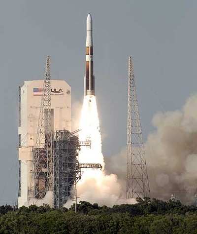
GOES-O was launched on a Delta IV rocket Saturday at 6:51 p.m.
Eastern time from Space Launch Complex 37B at Cape Canaveral Air
Force Station, Fla. Boeing commercial launch business Boeing Launch
Services procured the vehicle and mission services from United
Launch Alliance.
Sunday's signal acquisition marks the second successful launch
in the GOES N-P series and the latest step in enhancing
NOAA’s Earth-observation and weather-monitoring capabilities.
GOES-O, which is designed for a minimum orbit life of 10 years,
will be placed in on-orbit storage and may replace an older GOES
satellite in 2010. Together with GOES-13 (formerly GOES N), which
launched on May 24, 2006, GOES-O will provide complete coverage of
the Western Hemisphere.
The three-axis Boeing 601 spacecraft includes an imager that
produces visible and infrared images of the Earth’s surface,
oceans, cloud cover and storm developments; a multispectral sounder
that provides vertical temperature and moisture profiles of the
atmosphere; and a solar X-ray imager that monitors the sun’s
X-rays for early detection of solar flares. GOES-O also carries
space environment monitoring instruments that will measure X-rays
and extreme ultraviolet and particle emissions, including solar
protons, alpha particles and electrons. The GOES-O communications
subsystem also includes a search-and-rescue capability to detect
distress signals from ships and airplanes.
More News
Aero Linx: International Federation of Airworthiness (IFA) We aim to be the most internationally respected independent authority on the subject of Airworthiness. IFA uniquely combi>[...]
Ultrahigh Frequency (UHF) The frequency band between 300 and 3,000 MHz. The bank of radio frequencies used for military air/ground voice communications. In some instances this may >[...]
A Few Questions AND Answers To Help You Get MORE Out of ANN! 1) I forgot my password. How do I find it? 1) Easy... click here and give us your e-mail address--we'll send it to you >[...]
From 2019 (YouTube Edition): Learning To Paint Without Getting Any On Your Hands PPG's Aerospace Coatings Academy is a tool designed to teach everything one needs to know about all>[...]
Also: Sustainable Aircraft Test Put Aside, More Falcon 9 Ops, Wyoming ANG Rescue, Oreo Cookie Into Orbit Joby Aviation has reason to celebrate, recently completing its first full t>[...]
 ANN's Daily Aero-Linx (05.06.25)

