PC Aviator Launches MegaSceneryEarth For FSX | Aero-News Network
Aero-News Network
RSS icon RSS feed
podcast icon MP3 podcast
Subscribe Aero-News e-mail Newsletter Subscribe

Airborne Unlimited -- Most Recent Daily Episodes

Episode Date

Airborne-Monday

Airborne-Tuesday

Airborne-Wednesday Airborne-Thursday

Airborne-Friday

Airborne On YouTube

Airborne-Unlimited-04.22.24

Airborne-Unlimited-04.16.24

Airborne-FlightTraining-04.17.24 Airborne-AffordableFlyers-04.18.24

Airborne-Unlimited-04.19.24

Join Us At 0900ET, Friday, 4/10, for the LIVE Morning Brief.
Watch It LIVE at
www.airborne-live.net

Sat, Dec 27, 2008

PC Aviator Launches MegaSceneryEarth For FSX

Hyper-Realistic Photo-Scenery On-Demand

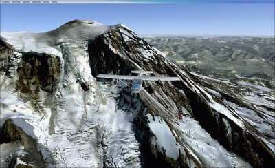
MegaScenery publisher PC Aviator, in partnership with MegaScenery developer Aerosoft Australia Pty Ltd, announced Friday the launch of the next evolutionary phase of the MegaScenery brand -- MegaSceneryEarth.

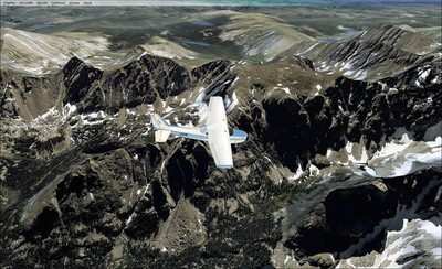
MegaSceneryEarth is a product line that involves the massive project of mapping as much of the earth as possible as ready-to-use photoscenery (created from aerial photography) for Microsoft Flight Simulator X. The focus initially will be on the continental USA.

End users visit the MegaSceneryEarth website, choose the pre-created areas of photoscenery packaged as tiles varying between 1200 and 2800 square miles and download them instantly after purchase.

While the concept of downloaded software is certainly not new, the concept of a megastore of on-demand, ready-to-use photoscenery for Microsoft Flight Simulator available for instant download is as a result of the MegaSceneryEarth model.

Aerial photographs for the MegaSceneryEarth product line are from source data of primarily 1 and (some) 2 meters per pixel resolution and are displayed in Microsoft Flight Simulator at 1.19 meters per pixel. The end result for the user is a very realistic representation of the particular area being flown in Flight Simulator.

As well as for entertainment, MegaScenery notes the product line also has sorts of positive implications for licensed and trainee pilots wanting to become familiar with visual flight operations in particular geographical areas.

This project was made possible as a result of the ever increasing speed of internet connection bandwidth for consumers however users who do not have fast connections the website also offers opportunities to have DVD recreations mailed on demand in lieu of downloading.

The pricing for the scenery tiles is as little as $3.00 per area when consumers take up maximum volume discounts.

FMI: www.megasceneryearth.com, www.pcaviator.com, www.aerosoft.com.au

Advertisement

More News

Airborne 04.16.24: RV Update, Affordable Flying Expo, Diamond Lil

Also: B-29 Superfortress Reunion, FAA Wants Controllers, Spirit Airlines Pulls Back, Gogo Galileo Van's Aircraft posted a short video recapping the goings-on around their reorganiz>[...]

ANN's Daily Aero-Term (04.20.24): Light Gun

Light Gun A handheld directional light signaling device which emits a brilliant narrow beam of white, green, or red light as selected by the tower controller. The color and type of>[...]

Aero-News: Quote of the Day (04.20.24)

"The journey to this achievement started nearly a decade ago when a freshly commissioned Gentry, driven by a fascination with new technologies and a desire to contribute significan>[...]

Aero-News: Quote of the Day (04.21.24)

"Our driven and innovative team of military and civilian Airmen delivers combat power daily, ensuring our nation is ready today and tomorrow." Source: General Duke Richardson, AFMC>[...]

ANN's Daily Aero-Term (04.21.24): Aircraft Conflict

Aircraft Conflict Predicted conflict, within EDST of two aircraft, or between aircraft and airspace. A Red alert is used for conflicts when the predicted minimum separation is 5 na>[...]

blog comments powered by Disqus


Advertisement

Advertisement

Podcasts

Advertisement

© 2007 - 2024 Web Development & Design by Pauli Systems, LC