KS Researchers Developing Vehicle To Study Antarctic, Greenland Ice Sheets | Aero-News Network
Aero-News Network
RSS icon RSS feed
podcast icon MP3 podcast
Subscribe Aero-News e-mail Newsletter Subscribe

Airborne Unlimited -- Most Recent Daily Episodes

Episode Date

Airborne-Monday

Airborne-Tuesday

Airborne-Wednesday Airborne-Thursday

Airborne-Friday

Airborne On YouTube

Airborne-Unlimited-04.22.24

Airborne-Unlimited-04.16.24

Airborne-FlightTraining-04.17.24 Airborne-AffordableFlyers-04.18.24

Airborne-Unlimited-04.19.24

Join Us At 0900ET, Friday, 4/10, for the LIVE Morning Brief.
Watch It LIVE at
www.airborne-live.net

Tue, Sep 18, 2007

KS Researchers Developing Vehicle To Study Antarctic, Greenland Ice Sheets

UAV Will Peer Underneath Glaciers For Water

Researchers in Kansas are building an unmanned aircraft, to better map and understand Antarctic and Greenland ice-sheet disintegration.

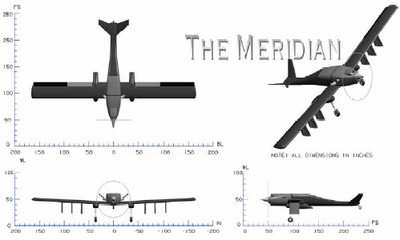
Carrying ground-penetrating radar, the Meridian Unmanned Aerial Vehicle is designed to peer beneath the glacier to see if any water lies between it and the ground. This information is critical in predicting when the ice might slip off into the ocean and causing ocean levels to rise.

Using a UAV for this mapping work will cut the risk to human pilots, who can fly only limited missions. It  will also speed up the mapping process.

"We can cut costs for large-scale mapping projects, increase the range, and reduce dangers," said University of Kansas associate professor of aerospace engineering and team leader Rick Hale.

The radar Meridian will carry was developed by the university and other institutions and can provide detailed pictures of ice layers specifically the space between the bottom of the glacier and the ground, according to the MIT Technology Review.

"Basically, our radar can see deeper, and with better resolution, than any of the other competitors out there at the moment," says Claude Laird, a University of Kansas research scientist.

The 125 pound radar unit beams signals through the ice at several frequencies, then analyzes the time of the signals' return for a clear picture of ice and rock surface contours, water packets and subsurface ice layers.

Laird put the radar through its paces this summer during an overland expedition in Greenland to select a site for a future  ice-core drilling expedition.

The plane is designed to fly in conditions and low altitudes that would prove hazardous to a human pilot.

The UAV will have three means of communication -- remote control for takeoffs and landings, radio-frequency communications, for the times it is near a base camp, and satellite communications, for the times it is as far away as 372 miles from a base camp.

The UAV's wingspan of 26 feet will have de-icing abilities. The aircraft will also sport heaters to protect the electronic systems from the extreme cold.

Meridian is scheduled to make its maiden flight on Greenland in the summer of 2008. Providing all goes well, it will then be put to work during the Antarctic summer later on in the year, said Hale.

FMI: www.ku.edu

Advertisement

More News

Airborne 04.16.24: RV Update, Affordable Flying Expo, Diamond Lil

Also: B-29 Superfortress Reunion, FAA Wants Controllers, Spirit Airlines Pulls Back, Gogo Galileo Van's Aircraft posted a short video recapping the goings-on around their reorganiz>[...]

ANN's Daily Aero-Term (04.20.24): Light Gun

Light Gun A handheld directional light signaling device which emits a brilliant narrow beam of white, green, or red light as selected by the tower controller. The color and type of>[...]

Aero-News: Quote of the Day (04.20.24)

"The journey to this achievement started nearly a decade ago when a freshly commissioned Gentry, driven by a fascination with new technologies and a desire to contribute significan>[...]

Aero-News: Quote of the Day (04.21.24)

"Our driven and innovative team of military and civilian Airmen delivers combat power daily, ensuring our nation is ready today and tomorrow." Source: General Duke Richardson, AFMC>[...]

ANN's Daily Aero-Term (04.21.24): Aircraft Conflict

Aircraft Conflict Predicted conflict, within EDST of two aircraft, or between aircraft and airspace. A Red alert is used for conflicts when the predicted minimum separation is 5 na>[...]

blog comments powered by Disqus


Advertisement

Advertisement

Podcasts

Advertisement

© 2007 - 2024 Web Development & Design by Pauli Systems, LC