Global Hawk Collects Recon Data During Haiti Relief Efforts | Aero-News Network
Aero-News Network
RSS icon RSS feed
podcast icon MP3 podcast
Subscribe Aero-News e-mail Newsletter Subscribe

Airborne Unlimited -- Most Recent Daily Episodes

Episode Date

Airborne-Monday

Airborne-Tuesday

Airborne-Wednesday Airborne-Thursday

Airborne-Friday

Airborne On YouTube

Airborne-Unlimited-05.06.24

Airborne-NextGen-04.30.24

Airborne-Unlimited-05.01.24 Airborne-AffordableFlyers--05.02.24

Airborne-Unlimited-05.03.24

Wed, Jan 20, 2010

Global Hawk Collects Recon Data During Haiti Relief Efforts

Helping Determine The Extent Of Damage, Locate Potential Airfields

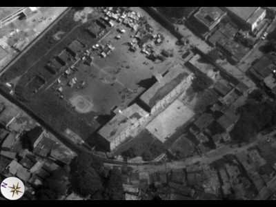
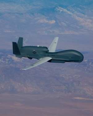
An RQ-4 Global Hawk is providing imagery to determine the extent of damage to earthquake-stricken Haiti and usability of its infrastructure, an Air Force official said during a Department of Defense Bloggers Roundtable January 15. "A lot of images of destroyed buildings," said Col. Bradley G. Butz, the 480th Intelligence, Surveillance and Reconnaissance Wing vice commander.


Photo Courtesy U.S. Air Force

They are looking at images of airports to find airfields to land aircraft, he added. The image quality and clarity is good enough whether or not an airfield can accept aircraft. "We've got pretty good coverage of the entire country of Haiti," Colonel Butz said.

The Global Hawk is a high-altitude, long-endurance unmanned aircraft with an integrated sensor suite that provides worldwide ISR capability.

The 480th ISR, based at Langley Air Force Base, VA, is providing its images to U.S. Southern Command officials for use by whomever needs the images, Colonel Butz said. The objective is mass distribution to people and organizations that need the images to support relief and recovery operations.

These images can help determine the level of destruction since aerial images of Haiti exist from June 2009. Comparing the June 2009 and the January 2010 can give an indication of the extent of the disaster. Without context "we just don't know the impact," the colonel said.

In addition, the Global Hawk provides assistance to Soldiers of the 82nd Airborne Division who are deploying to Haiti. The Global Hawk is providing images of where the Soldiers are deploying to help them prepare for their mission, Colonel Butz said.


File Photo

The Global Hawk flew 14 hours January 14, providing between 400 to 700 images, the colonel said. It is flying daily out of Naval Air Station Patuxent River, MD. The colonel said the Global Hawk will continue providing Haitian overflight support as long as the president requests.

This is the first use of the Global Hawk in a disaster relief mission in the Caribbean, according to the colonel.

FMI: www.af.mil

Advertisement

More News

ANN's Daily Aero-Term (05.09.24): Hold Procedure

Hold Procedure A predetermined maneuver which keeps aircraft within a specified airspace while awaiting further clearance from air traffic control. Also used during ground operatio>[...]

ANN's Daily Aero-Term (05.06.24): Altitude Readout

Altitude Readout An aircraft’s altitude, transmitted via the Mode C transponder feature, that is visually displayed in 100-foot increments on a radar scope having readout cap>[...]

ANN's Daily Aero-Linx (05.06.24)

Aero Linx: European Hang Gliding and Paragliding Union (EHPU) The general aim of the EHPU is to promote and protect hang gliding and paragliding in Europe. In order to achieve this>[...]

Airborne-NextGen 05.07.24: AI-Piloted F-16, AgEagle, 1st 2 WorldView Sats

Also: Skydio Chief, Uncle Sam Sues, Dash 7 magniX, OR UAS Accelerator US Secretary of the Air Force Frank Kendall was given a turn around the patch in the 'X-62A Variable In-flight>[...]

Aero-News: Quote of the Day (05.07.24)

"The need for innovation at speed and scale is greater than ever. The X-62A VISTA is a crucial platform in our efforts to develop, test and integrate AI, as well as to establish AI>[...]

blog comments powered by Disqus


Advertisement

Advertisement

Podcasts

Advertisement

© 2007 - 2024 Web Development & Design by Pauli Systems, LC