GerMap Introduces New Mapping Drone | Aero-News Network
Aero-News Network
RSS icon RSS feed
podcast icon MP3 podcast
Subscribe Aero-News e-mail Newsletter Subscribe

Airborne Unlimited -- Most Recent Daily Episodes

Episode Date

Airborne-Monday

Airborne-Tuesday

Airborne-Wednesday Airborne-Thursday

Airborne-Friday

Airborne On YouTube

Airborne-Unlimited-05.06.24

Airborne-NextGen-04.30.24

Airborne-Unlimited-05.01.24 Airborne-AffordableFlyers--05.02.24

Airborne-Unlimited-05.03.24

Tue, Jan 03, 2017

GerMap Introduces New Mapping Drone

G107-V Is A Hybrid Between Fixed-Wing And Multi-Rotor Aircraft

German mapping company GerMap has introduced a new purpose-built drone for use in its business.

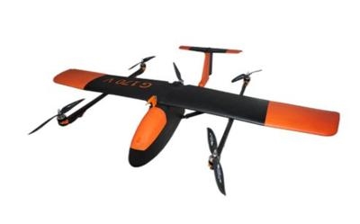
The G170-V is a vertical take-off and landing/VTOL fixed wing airplane UAV (unmanned airborne vehicle), perhaps better described as a QuadPlane.

Its 4 horizontal rotors give it quadcopter-like VTOL capabilities, and as a fixed wing airplane with 170 cm (67 inch) wingspan it operates like a regular fixed wing airplane.

The fuselage of G170-V houses a payload compartment which may carry up to 350 g (approx. 12 ounces) of payload. The maximum takeoff weight of this new, small QuadPlane amounts close to 4 kg (approx. 8 pounds).

G170-V covers large areas while remotely sensing data, e.g. within 20 min it covers an area of 25 ha in 100 m above ground level delivering with its 20 Mpix RGB-camera a stunning GSD of close to 4 cm. It accomplishes this with the convenience and easiness of its fully automatic vertical take-off and landing VTOL capabilities and combines thus flight coverage of fixed wing airplanes with handling simplicity of multicopters. Due to its 12 m/s (23 knots) cruise speed as airplane G170-V exploits time much more efficiently than a similar-powered multicopter.

Applications are in the domains of e.g. aerial mapping, corridor mapping, forestry, agriculture, security, environmental monitoring, construction, rapid disaster response, and many others more.

(Source: GerMap. Image courtesy GerMap)

FMI: www.germap.com/en

Advertisement

More News

ANN's Daily Aero-Term (05.09.24): Hold Procedure

Hold Procedure A predetermined maneuver which keeps aircraft within a specified airspace while awaiting further clearance from air traffic control. Also used during ground operatio>[...]

ANN's Daily Aero-Term (05.06.24): Altitude Readout

Altitude Readout An aircraft’s altitude, transmitted via the Mode C transponder feature, that is visually displayed in 100-foot increments on a radar scope having readout cap>[...]

ANN's Daily Aero-Linx (05.06.24)

Aero Linx: European Hang Gliding and Paragliding Union (EHPU) The general aim of the EHPU is to promote and protect hang gliding and paragliding in Europe. In order to achieve this>[...]

Airborne-NextGen 05.07.24: AI-Piloted F-16, AgEagle, 1st 2 WorldView Sats

Also: Skydio Chief, Uncle Sam Sues, Dash 7 magniX, OR UAS Accelerator US Secretary of the Air Force Frank Kendall was given a turn around the patch in the 'X-62A Variable In-flight>[...]

Aero-News: Quote of the Day (05.07.24)

"The need for innovation at speed and scale is greater than ever. The X-62A VISTA is a crucial platform in our efforts to develop, test and integrate AI, as well as to establish AI>[...]

blog comments powered by Disqus


Advertisement

Advertisement

Podcasts

Advertisement

© 2007 - 2024 Web Development & Design by Pauli Systems, LC